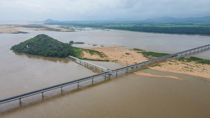
T Bridge, officially known as T-Setu, is a distinctive road bridge over the Mahanadi River in Cuttack district, Odisha. The bridge connects Gopinathpur in Badamba with Baideswar in Banki and also provides a branch towards Singhanath Pitha, an important religious site situated within the Mahanadi. Its unusual three-way alignment gives the structure the shape of the English letter “T”, from which its popular name comes.
The bridge is approximately 3.4 km long and 7.5 metres wide and was inaugurated on December 20, 2021. It was built at an estimated cost of ₹111 crore and significantly shortened the road journey between Badamba and Baideswar. At the time of opening, it was described as Odisha’s longest bridge.
Apart from improving everyday connectivity, T Bridge has made Singhanath Pitha easier to reach throughout the year. Earlier, temporary access arrangements across the Mahanadi riverbed were required for major religious gatherings and could disappear during the rainy season.
Quick Overview of T Bridge
| Particular | Details |
| Official Name | T-Setu |
| Common Name | T Bridge |
| Location | Cuttack district, Odisha |
| River | Mahanadi River |
| Bridge Type | T-shaped road bridge |
| Approximate Length | 3.4 km |
| Width | 7.5 metres |
| Connects | Gopinathpur, Baideswar and Singhanath Pitha |
| Main Areas | Badamba and Banki |
| Opened | December 20, 2021 |
| Construction Cost | About ₹111 crore |
| Pedestrian Facility | 1.5-metre footpaths on both sides |
| Nearby Places | Gopinathpur, Baideswar, Badamba, Banki and Singhanath Pitha |
| Known For | Distinctive T-shaped alignment and Mahanadi crossing |
| Major Benefit | Shortens Badamba–Baideswar travel by about 45 km |
The bridge was planned to benefit around five lakh people in nearby areas while supporting agriculture, trade, tourism and pilgrimage movement.
Where is T Bridge Located?
T Bridge is located across the Mahanadi River in Cuttack district, between the Badamba and Banki regions. One end is associated with Gopinathpur in Badamba, while another connects towards Baideswar in Banki. A separate arm provides access towards Singhanath Pitha, situated within the river.
The location is largely rural rather than urban. Instead of serving a dense city junction, the bridge links communities separated by the broad Mahanadi channel.
Before construction of the bridge, travelling directly between these areas required much longer routes. The permanent crossing reduced the Badamba–Baideswar distance by approximately 45 km, making everyday journeys considerably more convenient.
T Bridge Route and Road Connectivity
T Bridge provides an important connection within western Cuttack district and links settlements on different sides of the Mahanadi.
Important route connections include:
- Gopinathpur: Located on the Badamba side and one of the principal endpoints of the bridge.
- Baideswar: Important Banki-side settlement connected directly through T-Setu.
- Badamba: Major block and regional centre served by the bridge.
- Banki: Important town and administrative area connected through the Baideswar side.
- Singhanath Pitha: Religious destination reached through the bridge’s distinctive third arm.
- Athagarh region: Accessible through the wider road network from the Badamba side.
- Cuttack: The district’s main city, connected through regional roads from Banki and surrounding areas.
- Khordha-side areas: Residents of parts of neighbouring Khordha district also benefit from the shorter regional connection.
The bridge primarily improves local and regional journeys rather than serving as a major national highway crossing.
Why is T Bridge Important?
The biggest benefit of T Bridge is the reduction in travel distance between communities located on opposite sides of the Mahanadi.
Before the bridge opened, people travelling between Badamba and Baideswar could face an additional journey of around 45 km. The new road crossing created a direct connection and was expected to improve mobility for approximately five lakh residents of nearby areas.
The bridge supports several kinds of daily movement:
- Agricultural produce travelling towards markets
- Local business and commercial traffic
- Residents travelling for work
- Students and families making local journeys
- Pilgrims visiting Singhanath Pitha
- Visitors exploring the Mahanadi and Banki-Badamba region
Its value is therefore not limited to faster driving. It has connected communities that were historically separated by the river.
Why is it Called T Bridge?
The bridge gets its name from its unusual T-shaped road layout.
Most bridges connect two opposite banks in a relatively straight line. T-Setu is different because it links three points: Gopinathpur, Baideswar and Singhanath Pitha. Viewed from above, the meeting of these bridge sections resembles the English letter “T”.
This design is not simply decorative.
The third arm allows road access towards Singhanath Pitha without requiring an entirely separate long bridge from one of the riverbanks. It therefore combines regional connectivity and pilgrimage access within the same structure.
The unusual geometry has also made T-Setu a recognisable infrastructure landmark and a popular photography location.
Traffic Conditions on T Bridge
T Bridge does not normally experience the type of continuous congestion found on urban flyovers in cities such as Pune, Mumbai or Bengaluru.
Traffic mainly consists of local cars, two-wheelers, buses, commercial vehicles and people travelling between villages on either side of the Mahanadi. Pilgrimage traffic can become much heavier during important religious events associated with Singhanath Pitha.
During major festivals, authorities may introduce special traffic restrictions.
For example, vehicle movement towards Singhanath Temple through T Bridge has previously been temporarily prohibited during Jagara Jatra to manage the large number of devotees. Such restrictions are event-specific rather than permanent bridge rules.
Visitors travelling during major temple festivals should therefore check local police or district traffic advisories before starting their journey.
T Bridge and Singhanath Pitha
One of the most interesting features of T Bridge is its direct association with Singhanath Pitha, a well-known religious site located within the Mahanadi.
Before the permanent bridge existed, access during major gatherings was more difficult. The state government previously constructed a roughly 3-km fair-weather pedestrian track across the riverbed for devotees. This temporary route would be washed away during the rainy season and needed to be recreated when required.
T-Setu provided a permanent alternative.
The bridge is particularly useful during Bali Makar Jatra, when large numbers of devotees visit the Singhanath shrine. Improved access has also helped increase the tourism potential of the surrounding Mahanadi landscape.
Construction and History of T Bridge
The project had been planned for several years before construction was completed.
The foundation stone for T-Setu was laid on February 28, 2014. Technical issues delayed construction, and major work eventually began in 2018. The completed bridge was inaugurated on December 20, 2021.
The project cost approximately ₹111 crore.
Its main physical features include:
- Around 3.4 km total length
- Approximately 7.5-metre roadway width
- Pedestrian footpaths on both sides
- Approximately 1.5-metre-wide pedestrian spaces
- A three-direction T-shaped alignment
The bridge replaced the earlier Netaji Subhas Chandra Bose Setu over Kathajodi as the bridge widely described at that time as Odisha’s longest.
Pedestrian Access on T Bridge
Unlike many highway-only structures, T-Setu was built with pedestrian footpaths on both sides.
Each footpath is approximately 1.5 metres wide, providing space separate from the main roadway.
Pedestrian access is particularly useful for local residents and devotees travelling towards Singhanath Pitha.
However, during exceptionally crowded religious events, authorities can regulate both vehicle and pedestrian movement. Visitors should follow temporary barricades, police directions and event-specific access arrangements.
T Bridge and Regional Tourism
T Bridge has become a local attraction because of both its engineering and its setting over the Mahanadi.
The surrounding landscape is particularly striking when river levels are lower and large stretches of the Mahanadi riverbed become visible. The unusual T-shaped junction of the bridge can also be appreciated more clearly from elevated or aerial viewpoints.
The bridge supports tourism towards:
- Singhanath Pitha
- Badamba
- Banki
- Nearby Mahanadi river landscapes
- Other religious and natural attractions in western Cuttack district
At inauguration, the project was specifically expected to improve tourism, agriculture and commercial activity in the surrounding region.
Public Transport Near T Bridge
Road transport is the main way to reach the bridge.
Local buses and other road-based services operate through the wider Banki and Badamba regions, while cars, taxis and two-wheelers are commonly used for the final journey towards Gopinathpur, Baideswar and Singhanath Pitha.
There is no railway line running across T Bridge. It is a road bridge with pedestrian facilities, not a rail-cum-road structure.
Travellers arriving from farther away generally approach through the road network from Cuttack, Banki, Athagarh or neighbouring parts of Khordha district.
Nearby Areas to T Bridge
Gopinathpur: One of the principal endpoints of the bridge on the Badamba side.
Baideswar: Important Banki-side settlement connected directly through T-Setu.
Singhanath Pitha: Religious destination situated within the Mahanadi and connected by the third arm of the bridge.
Badamba: Important regional centre whose connectivity with Banki improved considerably after the bridge opened.
Banki: Major town on the opposite side of the wider Mahanadi corridor and an important local commercial centre.
Athagarh: Regional town accessible through the road network from the Badamba side.
FAQs About T Bridge Cuttack
Q1. Can visitors drive directly towards Singhanath Pitha using T Bridge?
The bridge includes a dedicated arm towards Singhanath Pitha, making road access significantly easier than before T-Setu was constructed. However, vehicles may be restricted during exceptionally crowded religious events.
Q2. Are vehicles restricted on T Bridge during major temple festivals?
They can be. Authorities have previously temporarily stopped vehicle movement on the bridge during major gatherings such as Jagara Jatra to manage pilgrim crowds. The restrictions depend on the event and should not be treated as permanent.
Q3. Can pedestrians use T Bridge?
Yes. The bridge was constructed with pedestrian paths approximately 1.5 metres wide on both sides of the roadway.
Q4. Was T Bridge built mainly for tourists?
No. Tourism and pilgrimage are important benefits, but the primary purpose is regional connectivity. The bridge reduces the journey between Badamba and Baideswar and serves residents, agriculture, businesses and everyday road traffic in the surrounding region.
Q5. Why was a permanent bridge especially useful during the monsoon?
Before T-Setu, temporary access arrangements across parts of the Mahanadi riverbed could be washed away during the rainy season. The permanent bridge provides a much more dependable year-round road connection.