Atal Bridge is one of the most distinctive landmarks on the Sabarmati Riverfront in Ahmedabad, Gujarat. Built exclusively as a pedestrian bridge across the Sabarmati River, it connects the eastern and western riverfront promenades between Ellis Bridge and Sardar Bridge. Unlike Ahmedabad’s conventional road bridges, Atal Bridge was created as both a functional river crossing and a public recreational space.
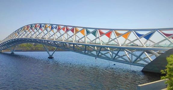
The bridge immediately stands out because of its unusual steel structure, colourful fabric panels and sweeping form. Its design takes inspiration from kites and Ahmedabad’s celebrated Uttarayan festival, giving the structure a visual identity closely linked with Gujarat. Seating areas, planters, glass-floor sections and changing LED illumination have helped turn it into a visitor attraction rather than simply a way to cross the river.
Atal Bridge was inaugurated on 27 August 2022 and is named after former Prime Minister Atal Bihari Vajpayee. Today, it is one of the signature features of the Sabarmati Riverfront and a popular stop for residents as well as tourists exploring central Ahmedabad.
Quick Overview of Atal Bridge
| Particular | Details |
| Name | Atal Bridge |
| Location | Sabarmati Riverfront, Ahmedabad, Gujarat |
| River | Sabarmati River |
| Bridge Type | Pedestrian bridge |
| Total Length | 300 metres |
| Middle Span | 100 metres |
| Width | 10 metres at the ends and 14 metres in the middle |
| Inaugurated | 27 August 2022 |
| Named After | Former Prime Minister Atal Bihari Vajpayee |
| Located Between | Ellis Bridge and Sardar Bridge |
| Connects | East and west Sabarmati Riverfront promenades |
| Design Inspiration | Kites and Gujarat’s Uttarayan festival |
| Vehicle Access | Not intended for regular motor vehicles |
| Nearest Major Railway Station | Ahmedabad Junction/Kalupur |
| Known For | Architecture, river views, colourful illumination and pedestrian experience |
The bridge measures 300 metres in length, with a 100-metre middle span. Its width varies from around 10 metres at either end to about 14 metres through the wider central portion.
Where is Atal Bridge Located?
Atal Bridge is located in the central section of the Sabarmati Riverfront, between the existing Ellis Bridge and Sardar Bridge. It crosses the Sabarmati River and provides a direct pedestrian connection between public spaces developed on the river’s eastern and western banks.
The western end connects with the riverfront area near the Flower Park and Event Ground, while the eastern end provides access towards the opposite promenade and adjoining central-city neighbourhoods.
Its central location makes the bridge convenient for visitors exploring both the modern riverfront and the older parts of Ahmedabad. Areas such as Ellisbridge, Paldi, Lal Darwaja and the historic city centre are within the wider surrounding zone.
Visitors can approach the bridge from both the upper and lower promenades on either bank, making it well integrated with the Riverfront’s walking network.
Atal Bridge Route and Road Connectivity
Although vehicles do not use Atal Bridge itself as a conventional road crossing, the surrounding Sabarmati Riverfront has good road connectivity.
The bridge sits between Ellis Bridge to the north and Sardar Bridge to the south, both of which carry road traffic across the Sabarmati. Riverfront roads on either bank provide access from several parts of central Ahmedabad.
Important connections around Atal Bridge include:
- Ellisbridge: Provides convenient access from the western and central parts of Ahmedabad.
- Paldi: A major residential and commercial locality close to the western riverfront.
- Lal Darwaja: Important central-city transport and commercial area on the eastern side.
- Ashram Road: One of Ahmedabad’s major commercial roads, running close to the western side of the Sabarmati.
- Old Ahmedabad: Historic neighbourhoods and markets on the eastern side can be reached through the central road network.
- Ahmedabad Junction: The city’s main railway station is around 5.5 km away according to Gujarat Tourism.
Travellers coming by car or cab generally reach one of the riverfront access roads and continue to the pedestrian entrance rather than attempting to cross Atal Bridge by vehicle.
Why is Atal Bridge Important?
Atal Bridge represents a different approach to urban bridges. Its primary purpose is not to move large volumes of cars across the river but to make walking and recreation part of the Sabarmati Riverfront experience.
Before such pedestrian connections were developed, crossing from one bank to another mainly depended on the city’s road bridges. Atal Bridge creates a dedicated connection between the east and west promenades without pedestrians having to use a conventional traffic corridor.
It also strengthens the relationship between recreational spaces on both banks. Visitors can walk from riverfront gardens and public spaces on one side to attractions on the opposite bank while remaining within the Riverfront precinct.
The bridge has also developed into a destination of its own. Gujarat Tourism describes it as more than simply a pathway across the river, noting that people visit specifically to spend time on the bridge and enjoy the riverfront environment.
Pedestrian Experience at Atal Bridge
Walking is the central experience at Atal Bridge. The structure is considerably wider than a typical footbridge, particularly through its middle section, where the width increases to about 14 metres.
The wider portion has been designed to allow visitors to stop without completely obstructing pedestrian movement. Seating, planters and food-and-beverage kiosks are incorporated into the central area.
Visitors can look along the Sabarmati River in both directions and get broader views of Ahmedabad’s riverfront skyline. The surrounding promenades make it possible to combine the bridge crossing with a longer walk along the river rather than treating it as an isolated attraction.
Evening is particularly associated with the bridge because its structural frame is fitted with dynamic colour-changing LED lights. The illumination highlights the geometry of the steel structure and colourful roof elements after sunset.
Design and Engineering of Atal Bridge
The architecture is perhaps the most interesting feature of Atal Bridge.
Its form draws inspiration from the colourful kites associated with Uttarayan, Ahmedabad’s famous kite festival. The coloured fabric elements incorporated into the bridge reflect this theme, while the changing geometry gives the structure a very different appearance when viewed from various points along the riverfront. The Prime Minister’s Office also highlighted the influence of Gujarat’s kite festival on the bridge when it was inaugurated.
Approximately 2,600 metric tonnes of structural steel were used in the bridge. Its engineering includes RCC pile foundations, spherical bearings at the supports and tensile-fabric roofing.
Other notable features include:
- Four transparent glass-floor sections
- Seating integrated with planters
- Tensile fabric roofing
- Food and beverage kiosks
- Dynamic LED illumination
- Access from different promenade levels
- Recreational space within the wider middle portion
Each glass-floor section covers about 24 sq m, according to Gujarat Tourism. These transparent areas add another visual element by allowing visitors to look down towards the river beneath portions of the walkway.
Engineering consultant Assystem states that the project involved developing the geometry of tubular structural members for the 300-metre crossing and was delivered using BIM-based design methods.
Atal Bridge and Sabarmati Riverfront
Atal Bridge cannot really be understood separately from the larger Sabarmati Riverfront project.
The Riverfront has transformed long stretches of the Sabarmati banks into promenades, gardens, recreational spaces, event areas and public facilities. Atal Bridge adds an important east-west pedestrian link within this network.
On the west bank, the bridge connects with the plaza between Flower Park and the Event Ground. On the eastern side, the connection was planned around public, cultural and exhibition-oriented development.
This integration means visitors can use the bridge as part of a broader Riverfront outing—walking along the promenade, visiting gardens and spending time beside the river.
Public Transport Near Atal Bridge
Atal Bridge is centrally located and can be reached using several forms of public transport.
City buses, auto-rickshaws and app-based cabs operate extensively throughout the surrounding central Ahmedabad areas. Visitors arriving by rail can travel from Ahmedabad Junction, also known as Kalupur Railway Station, which Gujarat Tourism places at approximately 5.5 km from the bridge.
Sardar Vallabhbhai Patel International Airport is approximately 11.9 km from Atal Bridge according to the same official tourism information, although actual road travel time varies with traffic.
For visitors already exploring central Ahmedabad, an auto or cab to the Sabarmati Riverfront is generally the simplest last-mile option.
Major Landmarks and Attractions Near Atal Bridge
- Sabarmati Riverfront Flower Park: Located close to the western end and one of the easiest attractions to combine with an Atal Bridge visit.
- Ellis Bridge: One of Ahmedabad’s historic river crossings and an important city landmark immediately north of Atal Bridge.
- Sardar Bridge: Major road bridge across the Sabarmati located south of Atal Bridge.
- Sidi Saiyyed Mosque: Famous historic mosque in central Ahmedabad, known for its intricately carved stone latticework.
- Old Ahmedabad: The historic core contains traditional neighbourhoods, markets, religious structures and heritage architecture.
- Manek Chowk: A well-known historic-city square that changes character through the day, functioning around market and food activity.
Nearby Areas to Atal Bridge
Ellisbridge: One of the closest major localities on the western side of the Sabarmati and well connected with central Ahmedabad.
Paldi: A prominent residential and commercial area south-west of the bridge with convenient access to the riverfront.
Lal Darwaja: Busy central Ahmedabad district on the eastern side, known for markets and public transport connections.
Khanpur: Located along the eastern side of the Sabarmati farther north and useful for reaching parts of the historic city.
Ashram Road: Major business and institutional corridor along the western side of the river.
FAQs About Atal Bridge Ahmedabad
Q1. What is the current entry fee for Atal Bridge?
Gujarat Tourism currently lists admission at ₹30 for adults and ₹15 for children and senior citizens. Entry is free for differently abled visitors. Since ticket rates can be revised, visitors planning a future trip should check the current official rate before travelling.
Q2. What are the current visiting hours of Atal Bridge?
The official Gujarat Tourism page currently lists visiting hours as 9:00 AM to 9:00 PM. Special events or administrative requirements can occasionally affect access.
Q3. Is there a combined Atal Bridge and Flower Park ticket?
Yes. The currently listed combined ticket costs ₹40 for adults and ₹20 for children and senior citizens, while differently abled visitors are admitted free. This option is useful for visitors planning to see both attractions during the same Riverfront outing.
Q4. Is Atal Bridge Ahmedabad the same as Atal Setu in Mumbai?
No. Atal Bridge in Ahmedabad is a 300-metre pedestrian bridge across the Sabarmati River. Atal Setu, officially the Mumbai Trans Harbour Link, is a much larger road sea bridge connecting Mumbai with Navi Mumbai. They are completely different bridges.
Q5. Do visitors have to enter Atal Bridge only from one side of the river?
No. Official information states that the bridge is accessible from both the eastern and western banks and from the upper as well as lower Riverfront promenades. This makes it possible to include the bridge in a longer Riverfront walk rather than returning through the same entrance.