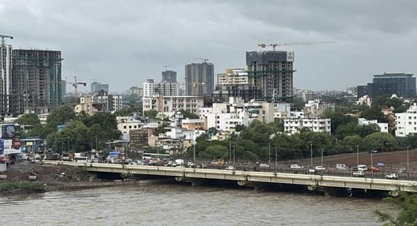
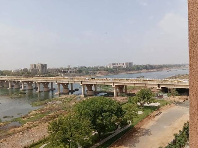
Indira Bridge is an important road bridge across the Sabarmati River in Ahmedabad, Gujarat. Located close to Sardar Vallabhbhai Patel International Airport, it forms a major part of the road corridor connecting Ahmedabad with Gandhinagar. The bridge is particularly important for motorists travelling between the airport, Hansol, Bhat, Koba and the state capital.
Built in 1983, the existing Indira Bridge is now more than four decades old. It currently carries six lanes of traffic and remains one of the key crossings on the Ahmedabad Airport–Koba–Gandhinagar corridor. The bridge also functions as an important alternative route when traffic is disrupted on other Sabarmati crossings in northern Ahmedabad.
The importance of Indira Bridge is set to increase further. In 2026, the Gujarat government approved a major expansion under which two new three-lane cable-stayed bridges are proposed on either side of the existing structure, ultimately creating a 12-lane river crossing.
Quick Overview of Indira Bridge
| Particular | Details |
| Name | Indira Bridge |
| Location | Ahmedabad, Gujarat |
| River | Sabarmati River |
| Bridge Type | Road bridge |
| Existing Configuration | Six lanes |
| Year Built | 1983 |
| Major Corridor | Ahmedabad Airport–Koba–Gandhinagar Road |
| Nearby Areas | Hansol, Sardarnagar, Koteshwar, Bhat and Airport area |
| Towards Ahmedabad | Airport Circle, Hansol, Shahibaug and central Ahmedabad |
| Towards Gandhinagar | Bhat, Koba and Gandhinagar |
| Public Transport | City buses, autos and app-based cabs in the surrounding corridor |
| Known For | Important Ahmedabad–Gandhinagar and airport road connection |
| Current Expansion Plan | Upgrade to a 12-lane corridor |
| New Structures Proposed | Two three-lane cable-stayed bridges |
Where is Indira Bridge Located?
Indira Bridge crosses the Sabarmati River in the northern part of Ahmedabad, close to the city’s airport corridor. On the Ahmedabad side, it connects with the Airport Road and areas such as Hansol and Sardarnagar. Beyond the river, the route continues towards Bhat and then onwards to Koba and Gandhinagar.
The bridge’s location makes it strategically different from many of Ahmedabad’s central Sabarmati crossings. Rather than mainly linking two inner-city neighbourhoods, Indira Bridge is an important gateway between Ahmedabad, Sardar Vallabhbhai Patel International Airport and Gandhinagar. Gujarat government records regularly identify locations near the bridge as being on the Ahmedabad–Gandhinagar Highway around Bhat.
Indira Bridge is also an important northern reference point for the expanding Sabarmati Riverfront. Riverfront development plans extend towards the bridge and farther north, increasing the infrastructure importance of the surrounding area.
Indira Bridge Route and Road Connectivity
Indira Bridge provides direct road connectivity between Ahmedabad’s airport side and the road leading towards Gandhinagar.
Important connections include:
- Sardar Vallabhbhai Patel International Airport: Located close to the Ahmedabad-side approach through Airport Circle.
- Hansol: One of the closest neighbourhoods to the bridge and airport.
- Sardarnagar: Accessible through the airport-side local road network.
- Bhat: Located beyond the bridge towards Gandhinagar.
- Koba: An important junction on the route towards Gandhinagar.
- Gandhinagar: The state capital is reached by continuing north from the bridge.
- Shahibaug: Connected through Airport Road and Dafnala-side routes.
- Koteshwar: Located along the Sabarmati side and connected through local roads.
- Naroda: Accessible through the eastern and northeastern Ahmedabad road network.
The corridor is also regularly used as an alternative airport route. For example, traffic diversions introduced during closures around Shahibaug have directed vehicles through Indira Bridge and Airport Road.
Why is Indira Bridge Important?
Indira Bridge performs several transport functions simultaneously.
Its most important role is providing a major road connection between Ahmedabad and Gandhinagar. Government officials, business travellers and daily commuters regularly use this route to move between Gujarat’s largest city and the state capital.
The bridge is equally important for airport connectivity. Travellers approaching Sardar Vallabhbhai Patel International Airport from Gandhinagar, Koba, Bhat and nearby areas can reach the airport through the Indira Bridge corridor without entering deeper into Ahmedabad.
It also serves as a backup crossing when traffic conditions change elsewhere. During the closure of Subhash Bridge in late 2025, Ahmedabad traffic police advised some motorists to use routes involving Bhat, Koteshwar, Indira Bridge and Airport Road.
The bridge therefore supports local, regional, airport and administrative traffic rather than serving only one neighbourhood.
Traffic Conditions at Indira Bridge
Traffic volume around Indira Bridge can be heavy, particularly during weekday office hours and periods of increased airport movement.
The pressure is often most noticeable around Indira Bridge Circle and the Airport Road T-junction, where vehicles from different directions converge before moving towards the bridge, airport or adjoining neighbourhoods.
The seriousness of this bottleneck was confirmed in a traffic study commissioned by Ahmedabad Municipal Corporation. In 2026, the Central Road Research Institute identified the Indira Bridge/Airport Road T-junction among Ahmedabad’s six priority congested junctions being considered for future grade-separated infrastructure.
Traffic can also increase when nearby bridges or major roads are closed, as diverted vehicles are shifted towards the Indira Bridge corridor.
Airport traffic creates another challenge because journey times matter more for passengers trying to reach flights. Motorists travelling during busy hours should therefore allow additional time rather than relying on a fixed journey duration.
Indira Bridge Expansion to 12 Lanes
The most important development involving Indira Bridge is its proposed transformation into a much wider crossing.
In July 2026, the Gujarat Roads and Buildings Department moved ahead with plans to expand the corridor from the existing six lanes to 12 lanes.
Instead of simply widening the old structure, the project proposes construction of two new three-lane cable-stayed bridges, one on each side of the existing bridge. The original six-lane structure will remain between them and will also undergo renovation.
The tender value reported for the project is approximately ₹96.23 crore, while the overall project cost has been estimated at around ₹109 crore.
Once completed, the arrangement would provide:
- Six lanes on the existing bridge
- Three additional lanes on one side
- Three additional lanes on the other side
- A combined 12-lane corridor
- Wider pedestrian facilities
- Modern cable-stayed structures on both sides
The project has been planned in response to increasing traffic between Ahmedabad, the airport and Gandhinagar.
Pedestrian Improvements on the New Bridges
The Indira Bridge expansion is not limited to vehicle capacity.
The existing structure has a relatively narrow pedestrian space of around one metre. According to the 2026 project details, each new cable-stayed bridge is planned with a significantly wider footpath of around 2.5 metres.
Viewing areas overlooking the Sabarmati River have also been included in the proposed design.
This is a notable improvement because the existing bridge was primarily developed as a functional road connection. The new structures are being planned with greater attention to pedestrian space and the appearance of this important city-entry corridor.
Airport Road and Indira Bridge Corridor Development
The roads approaching Indira Bridge are also undergoing substantial improvement.
The stretch between Airport Circle and Indira Bridge Circle has been developed as an important city-entry or “iconic road” corridor. Project plans provided for a road approximately 1.7 km long and 60 metres wide, including main carriageways, service roads and wide pedestrian paths.
This route is particularly important because it handles airport traffic as well as vehicles travelling towards Gandhinagar.
Ahmedabad authorities are also studying longer-term solutions for airport congestion. One proposal being examined involves an elevated connection between the airport and Indira Bridge, which could further separate airport-bound traffic from local road movement. The concept was still under consideration rather than an approved operational project in the latest available reporting.
Structural Condition and Safety Inspection
Concerns were raised in early 2026 after markings on parts of Indira Bridge were described as cracks.
The Gujarat government subsequently clarified that the visible gaps were expansion joints rather than structural cracks. A joint inspection by Roads and Buildings Department engineers found no structural defect in the main bridge.
The government also said the bridge undergoes regular technical inspections and that a technical audit had found the main structure safe for vehicular use.
This is particularly relevant because the bridge dates from 1983. The upcoming expansion project includes renovation of the existing structure rather than replacing it entirely.
Sabarmati Riverfront Development Near Indira Bridge
Indira Bridge is becoming increasingly connected with Ahmedabad’s wider riverfront development.
The northern extension of the Sabarmati Riverfront reaches towards the Indira Bridge area and is intended to continue the public spaces, roads and landscaped river edges developed farther south.
In 2026, planning was also progressing for a much longer riverfront extension northwards in the direction of Gandhinagar and GIFT City. This could eventually strengthen road and recreational connectivity between the two cities along the Sabarmati corridor.
For Indira Bridge, this means the surrounding area is gradually changing from a primarily highway-and-airport gateway into part of a broader urban development corridor.
Public Transport Near Indira Bridge
Public transport in the wider Indira Bridge area is mainly road based.
City buses serve the airport, Hansol, Sardarnagar and adjoining northern Ahmedabad neighbourhoods. Autos and app-based cabs are widely used, especially for airport transfers and shorter journeys.
The bridge itself does not function as a railway or Metro crossing. Motorists, buses and other road vehicles use it to cross the Sabarmati.
Because of its position between Ahmedabad and Gandhinagar, the corridor is also extensively used by taxis and private vehicles travelling between the two cities.
Major Landmarks and Facilities Near Indira Bridge
Important places around the wider bridge corridor include:
- Sardar Vallabhbhai Patel International Airport: One of the most important landmarks near the bridge.
- Airport Circle: Major junction on the Ahmedabad-side approach.
- Indira Bridge Circle: Important road junction controlling movement towards the bridge and airport.
- Hansol: Established neighbourhood close to the airport and river.
- Koteshwar Mahadev Temple: Well-known religious landmark near the Sabarmati River.
- Bhat: Important locality on the Gandhinagar side of the bridge.
- Ahmedabad Cantonment: Located towards the Shahibaug and airport side.
- Sabarmati River: The river crossed by Indira Bridge.
Nearby Areas to Indira Bridge
- Hansol: One of the closest Ahmedabad neighbourhoods and closely associated with the airport corridor.
- Sardarnagar: Residential and commercial area around the airport side of northern Ahmedabad.
- Koteshwar: Located near the Sabarmati River and connected through roads towards Motera and Chandkheda.
- Bhat: Located beyond the bridge towards Gandhinagar and home to residential, institutional and commercial development.
- Shahibaug: Major Ahmedabad locality accessible through the Airport Road-Dafnala corridor.
- Koba: Important junction farther north on the road towards Gandhinagar.
- Motera: Major northern Ahmedabad locality known for the Narendra Modi Stadium and developing sports infrastructure.
FAQs About Indira Bridge Ahmedabad
Q1. Is there a toll for crossing Indira Bridge?
There is no separate toll plaza simply for crossing Indira Bridge. It functions as an urban and intercity road connection between Ahmedabad and the Gandhinagar side.
Q2. Will the existing Indira Bridge be demolished for the 12-lane project?
Current plans do not call for demolition of the existing six-lane bridge. Instead, it is to be renovated, while separate three-lane cable-stayed bridges are constructed on either side.
Q3. Will the new Indira Bridge be cable-stayed?
The two proposed additional bridges will use a cable-stayed design. The existing central bridge will remain part of the expanded corridor.
Q4. Will pedestrians get more space after the expansion?
Yes. The proposed new bridge structures are planned with approximately 2.5-metre-wide pedestrian paths, considerably wider than the roughly one-metre footpath on the existing bridge.
Q5. Why is Indira Bridge sometimes used as an alternative to other Sabarmati bridges?
Its northern location provides useful access between Gandhinagar, Bhat, Koteshwar, the airport and Ahmedabad. When central or northern crossings face closures or major congestion, traffic authorities can redirect suitable traffic through the Indira Bridge-Airport Road corridor.