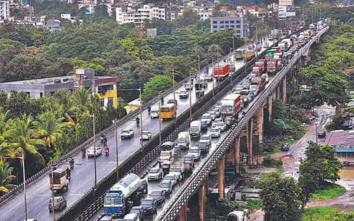
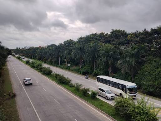
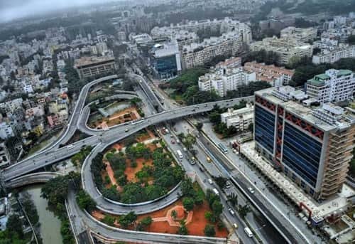
Domlur Bridge, more commonly known as Domlur Flyover or Airport Road Flyover, is one of the important road interchanges in eastern Bengaluru. Located at Domlur Junction, the structure helps manage traffic where Old Airport Road, Indiranagar 100 Feet Road and Inner Ring Road meet. These roads connect some of Bengaluru’s busiest residential, commercial and employment areas, including Indiranagar, Koramangala, HAL, Marathahalli and the Embassy Golf Links business district.
The main section of the flyover opened to traffic on 12 July 2006, with additional loops becoming operational afterwards. The structure was developed to reduce conflicts at what had become an increasingly congested junction as Bengaluru’s eastern IT and commercial corridors expanded.
Today, Domlur Bridge remains an important traffic landmark rather than a conventional river bridge. Its elevated ramps allow different streams of traffic to bypass parts of the surface junction, while roads below continue to serve local movements, buses and access to surrounding neighbourhoods.
Quick Overview of Domlur Bridge
| Particular | Details |
| Name | Domlur Bridge |
| Common Name | Domlur Flyover/Airport Road Flyover |
| Location | Domlur, Bengaluru, Karnataka |
| Structure Type | Urban flyover and multi-ramp interchange |
| Main Flyover Opened | 12 July 2006 |
| Major Road | Old Airport Road |
| Other Connecting Roads | Indiranagar 100 Feet Road and Inner Ring Road |
| Major Directions | Indiranagar, Koramangala, HAL, Marathahalli and central Bengaluru |
| Nearby Areas | Domlur, Indiranagar, HAL 2nd Stage, Kodihalli and Ejipura |
| Major Employment Hub | Embassy Golf Links |
| Public Transport | BMTC buses, autos and cabs |
| Major Bus Facility | Domlur TTMC |
| Nearby Metro Access | Indiranagar Metro Station |
| Known For | Busy multi-directional junction and eastern Bengaluru connectivity |
Domlur Flyover should be understood as a network of elevated ramps rather than one straight bridge span, which is why a single reliable overall bridge-length figure is not commonly used in official transport descriptions.
Where is Domlur Bridge Located?
Domlur Bridge is located at a strategic junction in eastern Bengaluru, close to Domlur Layout, HAL 2nd Stage and Indiranagar.
The flyover sits where three important urban corridors meet. Old Airport Road runs east-west through Domlur towards Kodihalli, Murugeshpalya, HAL and Marathahalli. Indiranagar’s 100 Feet Road approaches the junction from the north, while the Inner Ring Road continues south towards Embassy Golf Links, Ejipura and Koramangala.
This location makes Domlur a natural transition point between central Bengaluru and the eastern employment belt. People travelling from Indiranagar towards Koramangala or from central Bengaluru towards HAL and Marathahalli frequently pass through the wider interchange.
The area surrounding the bridge is densely developed with residential layouts, offices, defence properties, hotels, hospitals, restaurants and commercial establishments.
Domlur Bridge Route and Road Connectivity
Domlur Bridge handles several directions of traffic rather than serving one simple point-to-point route.
Important connections include:
- Indiranagar: Connected through 100 Feet Road, which terminates around the Domlur Flyover junction.
- Koramangala: Reached through Inner Ring Road towards Ejipura.
- HAL and Murugeshpalya: Accessible eastwards along Old Airport Road.
- Marathahalli: Reached farther east through the Old Airport Road corridor.
- Central Bengaluru: Accessible westwards towards Trinity Circle and adjoining central-city roads.
- Embassy Golf Links: Major office district located just off Inner Ring Road near Domlur.
- Ejipura: Located along Inner Ring Road between Domlur and Koramangala.
- Jeevan Bima Nagar: Accessible through local roads east and northeast of Domlur.
- Kodihalli: Located along Old Airport Road immediately east of the interchange.
The Inner Ring Road itself forms an important link between Indiranagar and Koramangala and historically became an important part of the IT-oriented road corridor connecting eastern Bengaluru with southern employment areas.
Why is Domlur Bridge Important?
Domlur Bridge is important because several major traffic streams converge within a relatively compact area.
Indiranagar generates substantial residential and commercial movement, while Koramangala is a major office, retail and residential district. Old Airport Road carries vehicles towards HAL, Murugeshpalya and Marathahalli, and Inner Ring Road serves commuters heading towards Embassy Golf Links and southern Bengaluru.
Without grade separation, much more of this traffic would need to pass through the same signal-controlled surface junction.
The flyover therefore performs two main functions: it allows through traffic to avoid parts of the intersection and helps separate some turning movements using elevated loops and ramps.
Its role is especially significant for office commuters because the Domlur-Inner Ring Road belt contains major employment centres. Embassy Golf Links, for example, is situated directly off the corridor and has historically housed numerous large corporate offices.
Traffic Conditions at Domlur Bridge
Traffic around Domlur Bridge can remain heavy despite the presence of the flyover.
The problem is largely caused by the number of major roads feeding traffic into the same corridor. Vehicles may move relatively smoothly over one elevated section but encounter slower conditions where ramps merge with Old Airport Road, 100 Feet Road or Inner Ring Road.
A recent detailed project report for a proposed larger elevated corridor through Indiranagar and Domlur described the wider route as experiencing high commuter volumes, stop-and-go movement and frequent peak-hour delays. The report placed typical speeds on the larger corridor at around 20–25 kmph.
Common pressure points around the area include:
- Old Airport Road approaches
- Indiranagar 100 Feet Road
- Inner Ring Road towards Embassy Golf Links
- Ejipura side during office hours
- Koramangala-bound movement
- Junctions where elevated traffic rejoins surface roads
Heavy rain can make the situation more difficult. During major rainfall in 2025, waterlogging was reported around the upper ramp of Domlur Flyover, contributing to traffic disruption.
For commuters, it is therefore more useful to check the entire Domlur-Indiranagar-Koramangala route rather than judging travel time only by whether the flyover itself appears clear.
History and Development of Domlur Flyover
The Domlur Flyover project began in the early 2000s as Bengaluru struggled with increasing traffic along Airport Road and the Inner Ring Road.
Construction started around 2003, but the project became known for delays and traffic difficulties during its development. The main elevated section was eventually opened on 12 July 2006, while the remaining loops were brought into service in stages over the following months.
The multi-ramp arrangement was significant because Domlur was not a simple four-road intersection. Traffic needed to move between Old Airport Road, Indiranagar and Inner Ring Road in several directions.
The design therefore developed into an elevated interchange with curved ramps and loops rather than a single straight flyover.
That layout remains one of the visual characteristics of Domlur today. Viewed from above, the interchange forms a series of curved elevated roads around the junction, allowing different traffic streams to enter or leave the main corridor.
Pedestrian Access Around Domlur Bridge
While the flyover helps motorists, pedestrian movement around the junction has remained more complicated.
A 2024 B.PAC proposal highlighted difficulty walking between Domlur, Indiranagar and the Inner Ring Road side because the ramps and fast-moving traffic create physical barriers at street level. Proposed improvements included pedestrian crossings, refuge islands, walkway connections and a possible foot overbridge near HAL-Old Airport Road.
The proposal also identified the need for better street lighting, lane markings and traffic-calming measures along sections of the surrounding Inner Ring Road corridor. Some lighting improvements had already been undertaken following safety audits.
This issue illustrates an important feature of Domlur Bridge: while its elevated design was intended primarily to improve vehicle movement, the junction must also accommodate large numbers of bus users, office employees and residents moving on foot.
Future Elevated Corridor Plans Around Domlur
Domlur may become part of another much larger elevated road project if current proposals move forward.
In 2025, BBMP’s broader traffic-management planning included an approximately 10-km elevated corridor from the Swami Vivekananda Metro Station side through Indiranagar and Domlur towards Madiwala and Silk Board.
By 2026, a detailed project report for a broader Old Madras Road-Silk Board elevated corridor had generated substantial debate. The proposed route would travel through Indiranagar towards Domlur before continuing south. Residents raised concerns about the effect of elevated structures on established neighbourhoods, while the Directorate of Urban Land Transport sought additional clarity on traffic benefits, safety and project design.
The proposal should therefore not be confused with an operational extension of Domlur Flyover. It remains part of wider infrastructure planning and assessment, and its eventual form could change.
If implemented, however, such a corridor would significantly alter traffic movement around Domlur because the existing flyover would become part of a much longer north-south/east-south elevated network.
Public Transport Near Domlur Bridge
Domlur has strong road-based public transport because it lies between several important residential and employment districts.
The Domlur Traffic Transit Management Centre (TTMC) is an official BMTC facility. BMTC lists Domlur among its TTMC locations, confirming its importance as a bus interchange and passenger facility.
BMTC buses travelling through the area provide connections towards destinations such as Indiranagar, HAL, Marathahalli, Koramangala, central Bengaluru and other parts of the city.
Auto-rickshaws and app-based cabs are also widely available throughout Domlur and the surrounding commercial districts.
For Metro travel, Indiranagar Metro Station on the Purple Line is one of the practical nearby options. Passengers generally need a short bus, auto or cab connection between the Metro and parts of Domlur, depending on their exact destination.
Major Landmarks and Facilities Near Domlur Bridge
Several important landmarks and facilities are located around the bridge:
- Embassy Golf Links Business Park: Major office and technology employment centre off Inner Ring Road.
- Domlur TTMC: Important BMTC bus facility near Old Airport Road.
- Domlur Layout: Established residential neighbourhood around the junction.
- HAL 2nd Stage: Residential and commercial area between Domlur and Indiranagar.
- Indiranagar 100 Feet Road: Major dining, retail and commercial street ending near the Domlur side.
- Manipal Hospital Old Airport Road: Major healthcare facility farther east along the corridor.
- Defence and military establishments: Several defence properties occupy significant land in and around the Domlur-HAL belt.
Restaurants, hotels, supermarkets, offices, hospitals and other everyday facilities are widely available along Old Airport Road, Indiranagar and surrounding neighbourhoods.
Nearby Areas to Domlur Bridge
- Domlur: The immediate neighbourhood surrounding the flyover and an important residential and office location.
- Indiranagar: Major residential, dining and commercial district connected through 100 Feet Road.
- HAL 2nd Stage: Established locality between Domlur, Indiranagar and Old Airport Road.
- Kodihalli: Located east of Domlur along Old Airport Road.
- Ejipura: Situated south of the bridge along the Inner Ring Road corridor.
- Koramangala: Major commercial, residential and employment destination reached through Inner Ring Road.
- Jeevan Bima Nagar: Residential neighbourhood accessible through local roads towards the HAL side.
- Murugeshpalya: Important Old Airport Road locality farther east towards HAL.
FAQs About Domlur Bridge Bengaluru
Q1. Does the name “Airport Road Flyover” mean Domlur Bridge leads directly to Bengaluru’s current airport?
No. The name comes from Old Airport Road, which historically served Bengaluru’s former HAL airport. Kempegowda International Airport is located north of the city near Devanahalli, so travellers heading to the current airport need to continue through Bengaluru’s wider road network rather than treating Domlur Flyover as the airport entrance.
Q2. Is there a toll for using Domlur Bridge?
No standalone toll is charged for using Domlur Flyover. It forms part of Bengaluru’s normal urban road network.
Q3. Is Domlur Bridge the same as the pedestrian footbridge near Domlur?
No. Domlur Flyover is the large vehicular grade separator carrying road traffic. Pedestrian footbridges and skywalk facilities in the surrounding area are separate structures intended for people crossing busy roads.
Q4. Can motorists reach Embassy Golf Links without going over the main flyover?
Yes. Embassy Golf Links is accessed from the Inner Ring Road/local road network, so the correct route depends on the direction from which a vehicle approaches. Drivers do not necessarily need to travel across every elevated section of Domlur Flyover to reach the business park.