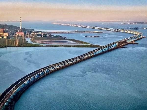
Atal Setu is one of Mumbai’s most important modern transport projects and the longest sea bridge in India. Officially named the Atal Bihari Vajpayee Sewri–Nhava Sheva Atal Setu, the six-lane sea link connects Sewri in Mumbai with the Nhava Sheva-Chirle side of Navi Mumbai. The complete corridor is approximately 21.8 km long, including about 16.5 km over the sea and 5.5 km on land.
Opened in January 2024, Atal Setu has created a much faster road connection between Mumbai and Navi Mumbai while strengthening access towards Jawaharlal Nehru Port, Panvel, the Mumbai-Pune corridor and the developing Navi Mumbai airport region. The bridge was constructed at a cost of more than ₹17,840 crore and is designed as an access-controlled high-speed road rather than a conventional city bridge.
Its importance will increase further as new connectors on both ends are completed, including the Sewri-Worli Elevated Connector and improved links towards the Mumbai-Pune Expressway and Navi Mumbai International Airport.
Quick Overview of Atal Setu Bridge
| Particular | Details |
| Official Name | Atal Bihari Vajpayee Sewri–Nhava Sheva Atal Setu |
| Common Name | Atal Setu / Mumbai Trans Harbour Link |
| Location | Mumbai Metropolitan Region, Maharashtra |
| Connects | Sewri in Mumbai with Nhava Sheva-Chirle side |
| Total Length | About 21.8 km |
| Sea Portion | About 16.5 km |
| Land Portion | About 5.5 km |
| Number of Lanes | Six |
| Bridge Type | Access-controlled sea link |
| Opened | January 2024 |
| Speed Limit | Up to 100 kmph for permitted vehicles |
| Current Car Toll | ₹250 one way under the 2026 concessional regime |
| Two-Wheelers/Autos | Not permitted |
| Known For | India’s longest sea bridge |
| Major Connections | Eastern Freeway, NH-348, JNPA, Panvel and Mumbai-Pune routes |
Official project information confirms the 21.8-km length and six-lane configuration, while the Maharashtra government extended the concessional toll arrangement through December 31, 2026.
Where is Atal Setu Bridge Located?
Atal Setu begins at Sewri on the eastern side of Mumbai, crosses the waters of Mumbai Harbour and Thane Creek, and reaches the mainland around the Nhava Sheva-Chirle area in Navi Mumbai.
The Mumbai-side alignment connects with the road network around Sewri and the Eastern Freeway. MMRDA’s original project alignment identifies Sewri Interchange as the starting point where the link connects with the Eastern Freeway corridor.
On the mainland side, the corridor reaches Chirle and connects with the wider road network towards Nhava Sheva, JNPA, Ulwe, Panvel and NH-348.
This alignment allows motorists travelling between South/Central Mumbai and Navi Mumbai to avoid the much longer routes through the traditional Vashi and Airoli crossings.
Atal Setu Bridge Route and Road Connectivity
The main strength of Atal Setu is the direct connection it creates across Mumbai Harbour.
Important route connections include:
- Sewri: Main Mumbai-side entry and exit point.
- Eastern Freeway: Provides onward access towards eastern and southern parts of Mumbai.
- Nhava Sheva: Major mainland-side destination close to Jawaharlal Nehru Port.
- Chirle: Important interchange at the Navi Mumbai end of the corridor.
- Ulwe: Developing Navi Mumbai locality with improving airport connectivity.
- JNPA/Jawaharlal Nehru Port: One of India’s most important container-port areas.
- Panvel: Major transport junction for routes towards Pune, Goa and southern Maharashtra.
- Mumbai-Pune Expressway: Accessible through onward roads from the Chirle-Panvel side.
- Navi Mumbai International Airport region: Atal Setu forms an important part of the broader road network planned to serve the new airport.
The Union government specifically identified improved connectivity to Mumbai’s airports, Navi Mumbai, Jawaharlal Nehru Port, Pune, Goa and South India among the major benefits of the project.
Why is Atal Setu Bridge Important?
Before Atal Setu opened, road travel between Mumbai and Navi Mumbai depended heavily on established crossings such as the Vashi and Airoli routes.
Atal Setu created a direct harbour crossing from Sewri to the Navi Mumbai mainland. This is particularly valuable for motorists starting from South Mumbai or central-eastern parts of the city and travelling towards Navi Mumbai, Panvel or destinations beyond.
Its importance extends beyond everyday commuting.
The bridge also improves access between Mumbai Port and Jawaharlal Nehru Port, making it relevant to freight and logistics movement.
MMRDA describes the project as a major regional-mobility link intended to improve connectivity between the island city and the mainland and reduce pressure on existing routes.
Traffic Conditions on Atal Setu
Traffic conditions on Atal Setu are quite different from those on a normal urban Mumbai bridge.
Because it is a six-lane access-controlled corridor, there are no ordinary roadside markets, frequent intersections, pedestrian crossings or traffic signals across the main sea section.
When traffic is flowing normally, motorists can therefore maintain relatively steady speeds.
Congestion is more likely to develop around:
- Sewri-side approach roads
- Interchange ramps
- Chirle and mainland connections
- Holiday travel periods
- Major traffic diversions elsewhere in Mumbai
- Vehicle breakdowns
- Heavy rain or unusually poor visibility
One of the main benefits of the bridge is the reduction in cross-harbour travel time. Government and project information indicated that the new link could bring typical Mumbai-Navi Mumbai crossing times down dramatically compared with older routes.
As road connections on either end improve, the practical benefit of the bridge should increase further.
Toll Charges and Vehicle Rules on Atal Setu
Atal Setu is a tolled access-controlled road.
For 2026, the Maharashtra government extended the concessional toll arrangement until December 31. Under this regime, the one-way toll for cars, SUVs and similar four-wheelers remains ₹250.
Electric four-wheelers and eligible electric buses have been granted full toll exemption under Maharashtra’s EV policy, although implementation initially faced some FASTag-related issues.
Not every vehicle category is allowed on Atal Setu.
Entry is prohibited for vehicles such as:
- Motorcycles and other two-wheelers
- Auto-rickshaws and other three-wheelers
- Tractors
- Certain slow-moving vehicles
These restrictions reflect the high-speed, controlled-access nature of the bridge.
The maximum permitted speed for eligible vehicles on the main corridor is generally 100 kmph, subject to traffic signs and any temporary restrictions.
Engineering and Design of Atal Setu
Atal Setu is notable not only for its length but also for the engineering required to construct a major highway across Mumbai Harbour.
The complete project runs for about 21.8 km, of which approximately three-quarters is over water. Its six traffic lanes are arranged as three lanes in each direction.
A major engineering feature of the project is the use of Orthotropic Steel Decks (OSDs) on long spans. This type of steel deck allowed longer bridge spans to be installed at locations where wider navigation clearance or other site conditions were required.
The bridge was also planned with:
- Emergency lanes
- Crash barriers
- Noise-control measures in sensitive areas
- Intelligent traffic systems
- Surveillance and monitoring
- Modern tolling infrastructure
The crossing is therefore designed more like an expressway over the sea than a conventional urban bridge.
Sewri-Worli Connector and Future Mumbai Connectivity
One major limitation of Atal Setu is that its Mumbai end currently reaches Sewri, while many motorists ultimately need to travel towards Worli, Prabhadevi and western Mumbai.
The Sewri-Worli Elevated Connector is being constructed to solve this problem.
The elevated road will connect the Atal Setu side of Sewri with Worli, creating a much more direct east-west connection across central Mumbai.
MMRDA project information has listed completion work extending through 2026, although reporting in July 2026 indicated that full opening was now expected in early 2027.
Once operational, the connector should make Atal Setu considerably more convenient for motorists travelling towards Worli and Mumbai’s western road network.
Atal Setu to Mumbai-Pune Expressway Connector
Another major project is underway on the Navi Mumbai side.
A 7.35-km signal-free connector is being developed between Atal Setu and the Mumbai-Pune Expressway corridor. The project includes an elevated section from Chirle and additional road works towards the expressway near Palaspe.
As of April 2026, construction was reported to be around 55% complete, with a target of February 2027.
This project is particularly important because vehicles leaving Atal Setu currently need to use intermediate roads before reaching the expressway.
A direct connector should eventually create a much smoother Mumbai-Pune journey through the sea link.
Connectivity to Navi Mumbai International Airport
Atal Setu is also central to plans for fast road access to Navi Mumbai International Airport.
New road infrastructure around Ulwe is being developed to link the bridge corridor more directly with the airport region. The Ulwe Coastal Road and associated airport connections are intended to avoid slower local routes and give travellers a more direct approach from Atal Setu.
This will be particularly useful for passengers starting from South Mumbai because the sea bridge already provides the fastest direct route to the mainland from the Sewri side.
As these connecting roads open, airport access is expected to become one of Atal Setu’s most important everyday functions.
Major Landmarks Near Atal Setu Bridge
Important landmarks and destinations around the wider Atal Setu corridor include:
- Sewri: Mumbai-side starting point of the bridge.
- Sewri Flamingo Point: Important ecological area along the eastern Mumbai waterfront.
- Mumbai Port: Major port area close to the Mumbai-side corridor.
- Jawaharlal Nehru Port: Major container port on the Navi Mumbai side.
- Nhava Sheva: Important port and transport area near the eastern end.
- Ulwe: Rapidly developing Navi Mumbai residential area.
- Navi Mumbai International Airport region: Major new transport destination linked with future road improvements.
- Chirle: Important mainland interchange and road-distribution point.
Nearby Areas to Atal Setu Bridge
- Sewri: The main Mumbai-side neighbourhood associated with the bridge and its western approach.
- Wadala: Important residential and transport area relatively close to the Sewri end.
- Parel: Major central Mumbai locality accessible from the bridge through the surrounding road network.
- Nhava Sheva: Port-oriented area close to the mainland side of Atal Setu.
- Ulwe: Large developing residential locality benefiting substantially from improved Mumbai connectivity.
- Uran: Important town in Raigad district connected with the Nhava Sheva and port region.
- Panvel: Major road and railway hub providing onward connections towards Pune and other destinations.
FAQs About Atal Setu Bridge Mumbai
Q1. Can motorists stop on Atal Setu to take photographs?
Atal Setu is an access-controlled high-speed road, not a sightseeing promenade. Motorists should not stop on the bridge for photographs or sightseeing. Stopping should be limited to genuine emergencies or situations directed by authorities.
Q2. Are motorcycles allowed on Atal Setu?
No. Two-wheelers are prohibited on Atal Setu. Motorcyclists travelling between Mumbai and Navi Mumbai need to use alternative road crossings.
Q3. Is Atal Setu toll-free for electric cars?
Electric four-wheelers are covered by Maharashtra’s toll-exemption policy for Atal Setu. The government has also continued the EV toll-relief arrangement in 2026.
Q4. What happens if a vehicle breaks down on Atal Setu?
The bridge has emergency infrastructure and monitoring systems for incidents and breakdowns. Drivers should move to a safe emergency area where possible, use hazard lights and follow instructions from bridge or traffic authorities rather than leaving the vehicle in an active traffic lane.
Q5. Will Atal Setu provide a direct road to the Mumbai-Pune Expressway?
Not yet as a completely seamless corridor. A dedicated 7.35-km connector between the Chirle side and the Mumbai-Pune Expressway is under construction and was targeting completion in 2027.