Padaharam Bridge is a major road crossing in Kuttanad, Alappuzha district, Kerala. Built across the Pampa River, the bridge links the Thakazhi and Nedumudi grama panchayats and creates an important connection between two of Kuttanad’s key road corridors. It lies on the Kuppappuram-Karuvatta route and helps connect the Alappuzha-Changanassery Road, commonly called AC Road, with the Ambalappuzha-Thiruvalla Road.
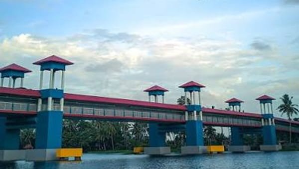
The bridge is especially notable for its two-level design. Vehicles use the 7.5-metre-wide road deck above, while separate pedestrian pathways run below the main deck on both sides. Eight Kerala-style watchtowers were also built into the project, giving the bridge a tourism role in addition to its everyday transport function.
Padaharam Bridge was developed with Kerala Infrastructure Investment Fund Board funding and Kerala Road Fund Board supervision. After a long construction period, it was formally inaugurated on 7 March 2026 along with the upgraded AC Road. The new crossing is now one of the most distinctive pieces of road infrastructure in Kuttanad.
Quick Overview of Padaharam Bridge
| Particular | Details |
| Name | Padaharam Bridge |
| Location | Kuttanad, Alappuzha district, Kerala |
| River | Pampa (Pamba) River |
| Structure Type | Road bridge with lower-level pedestrian pathways |
| Length | 453 metres |
| Road Deck Width | 7.5 metres |
| Pedestrian Pathways | 1.70 metres wide on both sides below the main deck |
| Watchtowers | 8 Kerala-style watchtowers |
| Main Connection | Thakazhi and Nedumudi grama panchayats |
| Road Corridor | Kuppappuram-Karuvatta Road |
| Connects | AC Road with Ambalappuzha-Thiruvalla Road |
| Project Agency | Kerala Road Fund Board / Public Works Department |
| Project Cost | About ₹65.5 crore in current KIIFB project records |
| Inaugurated | 7 March 2026 |
| Known For | Kerala’s first bridge designed with an upper roadway and lower pedestrian pathways |
Where is Padaharam Bridge Located?
Padaharam Bridge is located in Kuttanad taluk in Alappuzha district, between the Thakazhi and Nedumudi panchayat areas. It forms part of the Kuppappuram-Karuvatta road corridor and crosses the Pampa river system in the low-lying Kuttanad landscape.
Its position is important because it sits between two major east-west and regional routes. On one side, travellers can connect towards the Alappuzha-Changanassery Road. On the other side, roads lead towards the Ambalappuzha-Thiruvalla corridor. The surrounding area is characterised by paddy fields, canals, river channels and closely spaced Kuttanad villages rather than dense urban development.
Padaharam Bridge Route and Road Connectivity
The bridge has been designed as a practical cross-link inside Kuttanad. It reduces the need for longer detours between the AC Road side and the Ambalappuzha-Thiruvalla side and improves access for residents of the villages around Padaharam.
- Thakazhi: One of the two grama panchayats directly connected by the bridge and an important Kuttanad settlement.
- Nedumudi: The second directly connected panchayat, with road links towards Alappuzha and other Kuttanad areas.
- Karuvatta: An important approach direction on the Kuppappuram-Karuvatta corridor.
- Kuppappuram: Forms the opposite road-side reference point of the corridor on which Padaharam Bridge is aligned.
- AC Road: The Alappuzha-Changanassery Road can be reached through the connected local road network.
- Ambalappuzha-Thiruvalla Road: The bridge improves access towards this state-highway corridor and onward travel to Ambalappuzha and Thiruvalla.
- Champakulam: A major Kuttanad destination that benefits from the wider network of connecting roads around Nedumudi and Thakazhi.
Why is Padaharam Bridge Important?
Kuttanad’s network of rivers and canals makes bridges especially important for daily travel. Padaharam Bridge gives residents a direct road crossing where the waterway previously forced longer road movements through other links. It strengthens access between local villages, markets, schools, healthcare facilities and larger regional roads.
The bridge also improves the connection between the AC Road and the Ambalappuzha-Thiruvalla corridor. This is useful not only for local trips but also for traffic moving through central Kuttanad. As the surrounding road network develops, the crossing can distribute traffic more efficiently and reduce dependence on a small number of older routes.
Its design gives it a second role as a visitor attraction. The pedestrian level and watchtowers allow people to experience the river and paddy-field landscape without mixing directly with moving vehicles on the upper carriageway.
Traffic Conditions at Padaharam Bridge
Padaharam Bridge has been open to the public only since March 2026, so its long-term traffic pattern is still developing. The crossing is expected to carry a mix of local cars, two-wheelers, buses, goods vehicles and agricultural traffic travelling between the Thakazhi-Nedumudi side and the two larger road corridors.
Traffic pressure is likely to be higher during morning and evening local travel periods, festival days and times when visitors stop in the area for river and paddy-field views. Kuttanad is also sensitive to heavy monsoon conditions. During periods of intense rain or unusually high water, drivers should follow local traffic directions and avoid stopping on the carriageway.
Bridge Design and Special Features
The engineering layout is what makes Padaharam Bridge different from a conventional road bridge. The completed bridge is 453 metres long. Its span arrangement consists of three 45-metre central spans, six 35-metre spans and nine 12-metre spans.
The upper level carries the 7.5-metre-wide road. Below the main deck, pedestrian pathways about 1.70 metres wide are provided on both sides. The project also includes eight watchtowers designed with elements inspired by traditional Kerala architecture. These towers create viewing points over the Kuttanad fields and waterways.
This upper-road and lower-pedestrian arrangement is the reason Padaharam is widely described as Kerala’s first pathway bridge of its kind. The design combines transport, pedestrian movement and landscape viewing within one structure.
History of Padaharam Bridge
The Padaharam Bridge project was announced in Kerala’s 2016-17 budget period. The Kerala Road Fund Board was entrusted with project implementation, with funding support through KIIFB. Administrative and financial approvals were followed by tendering, land acquisition and approach-road works.
Construction activity began in 2019 but the project faced delays before reaching completion. By early 2025, the main bridge structure and most finishing works were nearing completion. The final project was formally opened on 7 March 2026, when the Kerala government inaugurated Padaharam Bridge together with the renovated Alappuzha-Changanassery Road.
Padaharam Bridge and Kuttanad Tourism
Unlike many regional bridges that function only as transport links, Padaharam Bridge was planned with the tourism potential of Kuttanad in mind. The lower pedestrian paths and eight watchtowers provide places from which visitors can look across the Pampa river system, waterways and surrounding paddy fields.
The design is particularly suited to Kuttanad, where the landscape itself is a major attraction. The bridge can complement nearby backwater, village and agricultural tourism, although it remains an active road crossing first. Visitors should keep vehicles away from traffic lanes and use the pedestrian areas rather than treating the road deck as a stopping point.
Public Transport Near Padaharam Bridge
Public transport in this part of Kuttanad is mainly road-based. KSRTC and private buses operate on the larger AC Road and Ambalappuzha-Thiruvalla corridors, while local buses, autorickshaws and taxis serve nearby villages and junctions. Depending on the service and starting point, travellers may need a short last-mile road connection to reach the bridge itself.
For visitors coming from outside Kuttanad, Alappuzha, Ambalappuzha, Thakazhi and Thiruvalla are useful transport reference points. Service frequency can vary by route and time of day, so same-day local bus information is more reliable than assuming every regional service passes directly over the bridge.
Major Landmarks and Places Near Padaharam Bridge
- Pampa River: The river system crossed by the bridge and the main natural feature of the location.
- Kuttanad paddy fields: The low-lying agricultural landscape visible around the bridge and from its viewing points.
- Thakazhi: Important nearby village and panchayat, also associated with the literary heritage of Thakazhi Sivasankara Pillai.
- Nedumudi: Major Kuttanad locality on the opposite side of the bridge connection.
- AC Road: The upgraded Alappuzha-Changanassery corridor that forms one of the main regional connections served by the bridge.
- Ambalappuzha-Thiruvalla Road: Major road corridor reached through the Padaharam connection.
Nearby Areas to Padaharam Bridge
- Padaharam: The locality directly associated with the bridge.
- Thakazhi: Connected panchayat and one of the main approach areas.
- Nedumudi: Connected panchayat and key road link towards central Kuttanad and Alappuzha.
- Karuvatta: Important settlement on the road corridor associated with the bridge.
- Kuppappuram: Road-side locality forming part of the Kuppappuram-Karuvatta alignment.
- Champakulam: Well-known Kuttanad village reachable through the surrounding road network.
- Ambalappuzha: Important town and transport point towards the western side of the wider route network.
FAQs About Padaharam Bridge Alappuzha
Q. Is Padaharam Bridge part of NH66 or SH12?
The bridge itself is on the Kuppappuram-Karuvatta road corridor. It links the AC Road side with the Ambalappuzha-Thiruvalla Road, which is identified as SH12 in official project material. It also improves onward access towards NH66, but Padaharam Bridge is not an NH66 bridge.
Q. How much travel distance can Padaharam Bridge save?
NABARD’s 2026-27 Kerala infrastructure profile states that the bridge connection can reduce travel distance by about 10 km between the linked road corridors. The exact saving for an individual trip depends on the starting point and destination.
Q. Can motorists stop on the bridge to take photographs?
The road deck is an active traffic carriageway, so vehicles should not stop in moving lanes for photographs. The bridge was designed with separate pedestrian pathways and watchtowers, which are the appropriate areas for enjoying the views where access is permitted.
Q. Is Padaharam Bridge safe to visit during the monsoon?
The bridge is a permanent road structure, but Kuttanad can experience heavy rain, high water and local traffic controls during severe monsoon conditions. Visitors should follow official weather and traffic instructions and avoid restricted riverbank or flooded approach areas.