Borim Bridge is a major road bridge across the Zuari River in Goa. It carries National Highway 566, formerly NH-17B, between the Borim-Ponda side and Loutolim in South Goa. The bridge is one of the most important direct road links between Ponda and Margao and also serves traffic travelling towards Verna and the Mormugao Port side.
The existing bridge is a two-lane prestressed-concrete structure. A Ministry of Road Transport and Highways technical note records its length as 410.20 metres, overall width as 11.50 metres and carriageway width as 7.50 metres. The same official record states that it was constructed in 1986 and carries about 33,990 passenger car units of traffic per day.
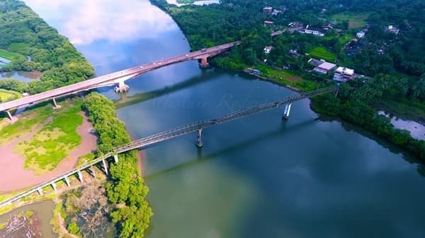
Borim Bridge is therefore best understood as a working highway bridge rather than a sightseeing structure. Its age, heavy traffic load and strategic position between East and South Goa have made maintenance, rehabilitation and plans for a replacement bridge important transport issues in the state.
Quick Overview of Borim Bridge
| Particular | Details |
| Common Name | Borim Bridge / Bori Bridge |
| Location | Between Borim and Loutolim, Goa |
| River | Zuari River |
| Road Corridor | NH-566 (former NH-17B) |
| Bridge Use | Two-lane vehicular road bridge |
| Total Length | 410.20 metres |
| Overall Width | 11.50 metres |
| Carriageway Width | 7.50 metres |
| Main Central Span | 121 metres |
| Superstructure | Prestressed-concrete cantilever box girder |
| Foundation | Mainly well foundations; open foundation at the Madgaon-side abutment |
| Construction Year | 1986, according to Goa PWD/MoRTH technical records |
| Recorded Traffic | About 33,990 PCU per day |
| Main Connections | Ponda, Borim, Loutolim, Margao, Verna and Mormugao-side routes |
Where is Borim Bridge Located?
Borim Bridge crosses the Zuari River on the NH-566 corridor. The Ponda-side approach is associated with Borim and nearby Shiroda road connections, while the southern approach enters the Loutolim side of Salcete. The bridge provides a direct connection between the Ponda region and the Margao-South Goa road network.
NH-566 runs from the Farmagudi-Ponda side through Borim and Loutolim towards Verna and the Mormugao Port corridor. This places Borim Bridge on an important east-to-south transport axis rather than on Goa’s main coastal NH-66 route. Official project documents identify NH-566 as passing through Borim and Loutolim towards Verna and Mormugao.
Borim Bridge Route and Road Connectivity
A common road movement through the bridge is broadly:
Ponda / Farmagudi → Borim → Borim Bridge → Loutolim → Margao-side roads or Verna
- Ponda: Major town and road hub on the eastern side of the bridge corridor.
- Borim: Village and immediate approach area from which the bridge takes its name.
- Loutolim: South Goa village on the opposite side of the Zuari crossing.
- Margao: Major commercial centre reached through the South Goa road network from Loutolim.
- Verna: Important industrial and highway junction reached farther west along NH-566.
- Mormugao Port direction: NH-566 continues towards the port-side network, giving the bridge a freight and commercial role as well as a passenger role.
Why is Borim Bridge Important?
The Ministry of Road Transport and Highways describes Borim Bridge as a lifeline for traffic movement between East and South Goa, particularly for connectivity between Ponda and Margao. Official records place its traffic volume at approximately 33,990 PCU per day.
Its importance becomes especially clear during closures. Alternative routes between Ponda and Margao are considerably longer, so even temporary repair restrictions can affect thousands of commuters, buses and commercial vehicles.
The bridge also provides a useful diversionary crossing of the Zuari. Goa authorities have previously diverted traffic towards Borim Bridge when the main Zuari crossing on NH-66 required closure.
Traffic Conditions at Borim Bridge
Borim Bridge carries a high volume of mixed highway traffic, including private cars, two-wheelers, buses and commercial vehicles.
Because the structure has only two traffic lanes, queues can develop quickly when one lane is restricted for repairs or when traffic slows at either approach. Rehabilitation activity during 2025 and 2026 required phase-wise and overnight closures, and heavy vehicles were temporarily prohibited during some critical work periods.
Drivers using the bridge should therefore follow current PWD and Traffic Police notices when maintenance work is underway.
Construction and Engineering of Borim Bridge
The existing Borim Bridge has a recorded total length of 410.20 metres.
Its main bridge section consists of:
- A 121-metre central span
- Two adjoining main spans
- Suspended-span sections
- A 149.6-metre viaduct section
- Four viaduct spans of 37.4 metres each
The main superstructure uses prestressed-concrete cantilever box girders. The viaduct uses simply supported prestressed-concrete box girders.
The bridge is supported mainly on well foundations. The Ponda-side abutment also uses a well foundation, while the Madgaon-side abutment is recorded as having an open foundation.
Maintenance and Rehabilitation
Borim Bridge has undergone repeated strengthening because of its age and structural condition.
External prestressing and other repair work were completed in 2018. Later inspections identified problems around bearings, suspended-span joints, expansion joints and concrete elements.
In January 2024, the Union road ministry sanctioned approximately Rs 20.67 crore for a major strengthening and rehabilitation programme. The approved work included:
- Replacement of bridge bearings
- Replacement of expansion joints
- Repair of damaged concrete
- Carbon-fibre strengthening
- Replacement of the road wearing course
- Load testing
- Crash barriers
- Road markings and signs
- Repairs around suspended-span components
Critical bearing work continued during 2025. Expansion-joint and road-surface work extended into 2026. Goa PWD completely closed the bridge overnight on February 8, 2026 to carry out polymer-modified bituminous road work and complete balance rehabilitation activities.
Existing Borim Bridge and the Old Borim Bridge
The present concrete Borim Bridge should not be confused with the earlier steel-truss crossing at the same river location.
The earlier bridge dated from the Portuguese period and was damaged during Goa’s Liberation period. It was subsequently repaired, but later became unsuitable for normal traffic. Goa eventually constructed the present bridge in the 1980s.
The remaining river portions of the older structure were cleared in 2023 because they posed difficulties for navigation. The PWD retained part of the old approach structure because of its historical significance.
For normal road travel today, Borim Bridge means the existing concrete NH-566 crossing.
Proposed New Borim Bridge
Goa has been pursuing another high-level Borim Bridge as a long-term solution for the ageing existing structure and increasing traffic demand.
In March 2026, the state reported a DPR estimated at approximately Rs 1,948 crore for a four-lane cable-stayed bridge project. The overall project, including approach roads, would extend for roughly 8 km.
However, the proposed bridge is not currently an operational replacement. On July 31, 2026, the Bombay High Court at Goa stayed implementation of the final land-acquisition declaration and restrained authorities from taking possession of the notified land or beginning construction under that declaration pending further proceedings. Statutory clearance work could continue.
The existing Borim Bridge therefore remains the main NH-566 river crossing.
Public Transport Near Borim Bridge
Public and private buses use roads through Borim and the wider Ponda-South Goa corridor. Local buses, taxis and other road transport also serve Borim, Loutolim, Shiroda and adjoining areas.
Ponda and Margao are the main transport centres on either side of the wider route. Goa government route information also identifies Borim Bridge as a recognised boarding or route point on some services travelling through the Ponda area.
When the bridge is temporarily closed, bus routes may be diverted along with normal traffic.
Major Road References Near Borim Bridge
- Zuari River: The river crossed by Borim Bridge.
- Borim Junction: Important road point on the Ponda side.
- Shiroda road connection: Provides access towards Shiroda and adjoining Ponda taluka areas.
- Loutolim: Main settlement on the South Goa side of the bridge.
- Farmagudi / Ponda: Major eastern road hub connected through NH-566.
- Verna: Important industrial and highway area farther along the corridor.
Nearby Areas to Borim Bridge
- Borim: Immediate settlement associated with the bridge.
- Loutolim: Village on the South Goa side of the Zuari.
- Shiroda: Nearby settlement connected through local roads.
- Ponda: Major town east of the bridge and an important origin or destination for daily traffic.
- Margao: Major South Goa city reached through the Loutolim-side road network.
- Verna: Important industrial and transport hub farther along NH-566.
FAQs About Borim Bridge Goa
Q. Is Borim Bridge on NH-66?
No. Borim Bridge carries NH-566, formerly NH-17B. NH-66 crosses the Zuari farther west near Cortalim and Agassaim.
Q. Can heavy vehicles use Borim Bridge?
The bridge normally carries commercial vehicles, but authorities can temporarily prohibit or divert heavy traffic during rehabilitation work, inspections or scheduled closures.
Q. Why is Borim Bridge sometimes closed at night?
Recent night closures have allowed engineers to replace bearings and expansion joints, complete surfacing work and conduct rehabilitation without normal daytime traffic interfering with the work.
Q. Is the proposed new Borim Bridge already under construction?
No. As of August 2026, the proposed high-level bridge remains subject to legal and statutory processes. The existing NH-566 bridge continues to carry traffic.
Q. Is the old steel Borim Bridge used by traffic today?
No. The old crossing is a separate historical structure. Normal highway traffic uses the present concrete Borim Bridge on NH-566.