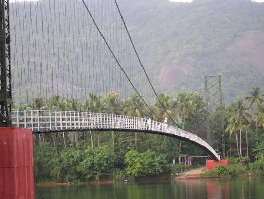
Inchathotty Suspension Bridge is a scenic pedestrian hanging bridge across the Periyar River in Ernakulam district, Kerala. Set within a forested river corridor near Kothamangalam and Thattekad, the bridge links the panchayats of Keerampara and Kuttampuzha. At about 185 metres long, Kerala Tourism describes it as Kerala’s longest pedestrian hanging bridge.
The bridge is important for two different reasons. For local residents, it provides a practical walking connection across the Periyar. For visitors, it has become a quiet eco-tourism stop known for broad river views, surrounding greenery and the gentle sway typical of a suspension footbridge.
Unlike a highway bridge, Inchathotty Suspension Bridge is not meant for cars, buses or normal motor traffic. Visitors reach the area by road, park or get down near the approach, and cross on foot. Kerala Tourism’s current destination information says the bridge remains in regular use while also functioning as a viewing structure.
Quick Overview of Inchathotty Suspension Bridge
| Particular | Details |
| Name | Inchathotty Suspension Bridge |
| Location | Inchathotty, Ernakulam district, Kerala |
| River | Periyar River |
| Bridge Type | Pedestrian suspension / hanging bridge |
| Approximate Length | 185 metres |
| Connects | Keerampara and Kuttampuzha panchayats |
| Vehicle Access | Not intended for normal motor vehicles |
| Main Use | Local pedestrian crossing and sightseeing |
| Current Status | In regular use |
| Nearest Main Town | Kothamangalam |
| Nearest Bus Stand | Kothamangalam, about 23.7 km from Inchathotty |
| Nearest Railway Station | Angamaly, about 57 km |
| Nearest Airport | Cochin International Airport, about 56 km |
| Nearby Tourism Area | Thattekad forest and bird sanctuary region |
| Known For | Long pedestrian suspension span, Periyar views and forest setting |
Where is Inchathotty Suspension Bridge Located?
Inchathotty Suspension Bridge is located in the eastern part of Ernakulam district, within the wider Kothamangalam–Thattekad region. It spans the Periyar River between the Keerampara and Kuttampuzha panchayat sides.
The setting is very different from an urban bridge. Dense vegetation, low forested hills and the broad river dominate the landscape. Kerala Tourism places the bridge within the larger Thattekad forest region, not far from the Thattekad Bird Sanctuary.
Kothamangalam is the most useful town for travellers approaching from the Kochi side. From there, visitors continue through smaller local roads towards Inchathotty and the river.
Inchathotty Suspension Bridge Route and Road Connectivity
The bridge itself is pedestrian-only, but the surrounding villages are connected by road. Visitors normally approach from Kothamangalam, Thattekad, Bhoothathankettu or the Neriamangalam side depending on their wider travel plan.
- Kothamangalam: Main nearby town and the most practical bus and road hub.
- Thattekad: Important eco-tourism area known for the Salim Ali Bird Sanctuary.
- Bhoothathankettu: Popular dam, boating and trekking destination that can be combined with Inchathotty.
- Neriamangalam: Useful road-side settlement for travellers coming from the Munnar or Idukki direction.
- Kuttampuzha: One of the panchayat areas directly connected by the bridge.
- Keerampara: The panchayat on the opposite side of the crossing.
- Munnar direction: Inchathotty can be included as a detour on journeys through the eastern Ernakulam–Idukki hill corridor.
Why is Inchathotty Suspension Bridge Important?
Inchathotty is not merely a tourist photo spot. Kerala Tourism identifies it as a functioning local crossing between Keerampara and Kuttampuzha panchayats. Earlier reporting also described it as a lifeline for families who depended on the bridge to reach nearby towns.
The suspension bridge saves pedestrians from relying entirely on longer road journeys around the river. For students, workers and local residents, that practical role is more important than its tourism value.
At the same time, its unusual length and location have made it one of Ernakulam district’s better-known low-key nature attractions.
Traffic and Access Conditions at Inchathotty Bridge
There is no normal car, bus or truck traffic on the bridge deck. The structure is designed primarily for pedestrians and light movement. This means the word ‘traffic’ here refers mainly to people using the crossing and to road conditions on the approaches.
The bridge naturally moves slightly when several people are walking on it. Kerala Tourism describes this as a gentle sway and treats it as an expected characteristic of the suspension structure.
On weekends and holidays, tourist footfall can be higher. The approach roads are rural and narrower than city roads, so parking and vehicle movement near the bridge can become less convenient during busy periods. Visitors should avoid blocking local access because the bridge and surrounding roads still serve residents.
Bridge Design and Walking Experience
The bridge uses a classic pedestrian suspension arrangement. The narrow deck hangs below main cables, with vertical suspenders transferring the deck load to the cable system and towers.
Kerala Tourism gives the bridge length as approximately 185 metres. Older travel references frequently mention about 183 metres, but the current official tourism description uses 185 metres, making that the better figure to use.
Walking across gives an uninterrupted view of the Periyar, forested banks and distant hills. The mild movement of the deck is part of the experience, but visitors should walk normally rather than deliberately shaking the structure or crowding one spot.
Inchathotty as an Eco-Tourism Stop
The landscape around the bridge is a major part of its appeal. The Periyar runs through a green corridor where traditional boats, fishing activity and occasional kayakers can be seen below.
Kerala Tourism specifically promotes Inchathotty for kayaking. Its 2023 tourism feature describes the area as a favourite kayaking destination and recommends early morning for calmer conditions, mist over the water and better chances to appreciate the surrounding birdlife.
The combination of bridge walking and water-based activities makes Inchathotty suitable for a half-day nature outing rather than only a quick photo stop.
Best Time to Visit Inchathotty Suspension Bridge
Early morning and late afternoon are particularly attractive because temperatures are usually more comfortable and the light over the river is softer. Kerala Tourism also notes that morning conditions can be especially pleasant for kayaking.
Monsoon and post-monsoon months bring richer greenery and stronger river scenery, but heavy rain can make local roads slippery and raise river levels. Visitors should follow local instructions during periods of intense rainfall.
For a relaxed visit, weekdays are generally preferable to busy weekends and public holidays.
Public Transport Near Inchathotty Suspension Bridge
Public transport is easiest up to Kothamangalam. Kerala Tourism lists Kothamangalam Bus Stand, around 23.7 km away, as the nearest major bus point for the Inchathotty kayaking area. From there, visitors can use a taxi, auto-rickshaw or other local road transport.
For rail travellers, Kerala Tourism lists Angamaly Railway Station at about 57 km from Inchathotty. Cochin International Airport is about 56 km away.
Because the last part of the journey passes through a rural area, visitors relying entirely on public transport should plan their return transport in advance.
Major Attractions and Facilities Near Inchathotty Bridge
- Thattekad Bird Sanctuary: One of Kerala’s noted bird habitats, within the wider forest region around Inchathotty.
- Bhoothathankettu Dam: Popular Ernakulam district attraction offering river scenery, boating and trekking opportunities.
- Periyar River: The central natural feature of the area and the river crossed by the bridge.
- Kayaking at Inchathotty: Kerala Tourism promotes supervised kayaking in the river corridor.
- Kothamangalam: Main nearby town for food, buses, shops and other everyday services.
- Neriamangalam: Scenic gateway settlement useful for travellers continuing towards Idukki and Munnar.
Nearby Areas to Inchathotty Suspension Bridge
- Inchathotty: Quiet riverside village most closely associated with the bridge.
- Kuttampuzha: Forest-edge panchayat area on one side of the crossing.
- Keerampara: Panchayat linked with Kuttampuzha by the bridge.
- Thattekad: Important birding and eco-tourism destination in the same regional circuit.
- Kothamangalam: Principal nearby town and transport base.
- Neriamangalam: Hill-route settlement connecting this part of Ernakulam with Idukki.
FAQs About Inchathotty Suspension Bridge Kerala
Q1. Can cars or motorcycles cross Inchathotty Suspension Bridge?
No. It is a pedestrian hanging bridge rather than a road bridge for normal motor vehicles. Visitors use the surrounding road network to reach the bridge and then cross on foot.
Q2. Is Inchathotty Suspension Bridge open for visitors?
Kerala Tourism’s current 2026 destination information says the bridge remains in regular use and also functions as a viewing structure. Temporary restrictions can still be introduced locally during exceptional weather or maintenance.
Q3. Is there an official entry ticket for simply walking across the bridge?
Kerala Tourism does not publish a standard bridge-entry fee on its current destination page. Charges may apply separately to activities such as kayaking or other locally operated tourism services.
Q4. Can kayaking be combined with a visit to the bridge?
Yes. Kerala Tourism specifically promotes kayaking at Inchathotty, with the bridge forming one of the main landmarks of the river experience. Activity availability can depend on weather and local operating conditions.
Q5. Which is the most practical public-transport base for the bridge?
Kothamangalam is the most useful bus and town base. Kerala Tourism places Kothamangalam Bus Stand about 23.7 km from the Inchathotty kayaking destination, after which a taxi or auto is practical for the final journey.
Q6. Is the bridge suitable as part of a Thattekad trip?
Yes. Inchathotty lies within the wider Thattekad forest region, so the bridge can be combined with Thattekad Bird Sanctuary, Bhoothathankettu and other nearby nature attractions.