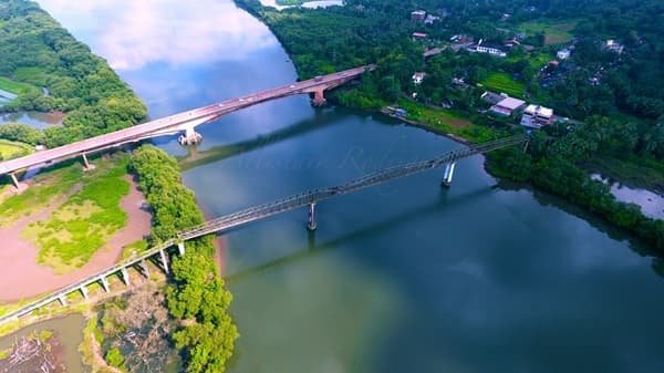
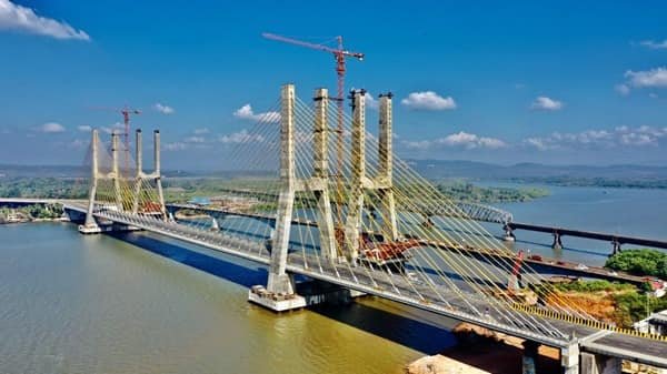
Zuari Bridge is one of Goa’s most important road crossings, carrying National Highway 66 across the Zuari River between Agassaim and Cortalim. The present landmark structure is the New Zuari Bridge, an eight-lane cable-stayed bridge built to strengthen the main road connection between North Goa and South Goa.
The first four-lane carriageway opened on 29 December 2022, while the second four-lane corridor followed in December 2023, making the bridge fully operational as an eight-lane crossing. The older Zuari Bridge still stands beside it and appears separately in traffic and maintenance notices.
Quick Overview of Zuari Bridge
| Particular | Details |
| Name | New Zuari Bridge |
| Location | Agassaim-Cortalim, Goa |
| River | Zuari River |
| Highway | NH-66 |
| Structure Type | Cable-stayed road bridge |
| River Bridge Length | 640 metres |
| Main Span | 360 metres |
| Traffic Capacity | Eight lanes |
| Phase I Opening | 29 December 2022 |
| Fully Operational | December 2023 |
| Project Length with Approaches | 13.20 km |
| Project Corridor | Bambolim-Verna |
| Project Cost | Rs 2,530 crore for the bridge-and-approach project stated at Phase I inauguration |
| Main Connection | North Goa with South Goa |
| Nearby Areas | Agassaim, Cortalim, Bambolim, Verna and Chicalim |
| Current Role | Main high-capacity road crossing over the Zuari |
Where is Zuari Bridge Located?
The New Zuari Bridge crosses the tidal Zuari River between Agassaim on the northern side and Cortalim on the southern side. It forms part of NH-66, Goa’s principal north-south highway.
Panaji lies to the north through Bambolim, while Margao is reached southward through Verna and Nuvem. Cortalim also gives access towards Vasco da Gama, Chicalim and Dabolim Airport.
Zuari Bridge Route and Road Connectivity
The bridge serves local, tourist and long-distance traffic.
- Panaji and North Goa: Reached northward through Bambolim.
- Agassaim: Immediate northern approach area.
- Cortalim: Main junction immediately south of the river.
- Verna: Major industrial and highway area south of Cortalim.
- Margao: Principal South Goa commercial centre on the wider NH-66 corridor.
- Vasco da Gama and Dabolim Airport: Connected from Cortalim through NH-366 and adjoining roads.
- Mormugao Port area: Reached through the Vasco-side road network.
Why is Zuari Bridge Important?
The Zuari River is a major physical divide between North and South Goa. As traffic increased over the years, dependence on the older crossing created pressure on this vital route.
The New Zuari Bridge significantly increased capacity. Its eight lanes support daily commuting, tourism, freight movement and airport access. The larger Bambolim-Verna project also improved the highway approaches on both sides.
Traffic Conditions at Zuari Bridge
The bridge carries cars, tourist taxis, buses, two-wheelers and commercial vehicles. Traffic can increase during weekday commuting hours, long weekends, tourist seasons and major events.
The eight-lane layout provides much greater capacity than the older bridge alone, but queues can still form at approach junctions. Drivers should follow temporary lane diversions and traffic-police instructions during maintenance or special traffic arrangements.
Bridge Design and Engineering Features
The river section of the New Zuari Bridge is about 640 metres long and uses a cable-stayed design, with two four-lane carriageways and a major central navigation span.
Its tall pylons and stay cables have made it a prominent modern landmark. The design provides a wide river opening while carrying heavy NH-66 traffic.
At the Phase I inauguration, the Ministry of Road Transport and Highways stated that the bridge and approaches between Bambolim and Verna covered 13.20 km and formed a Rs 2,530-crore project.
History and Opening of the New Zuari Bridge
The bridge was developed as part of the NH-66 improvement programme. Construction proceeded in two carriageway phases so traffic could use part of the new crossing before the entire eight-lane structure was finished.
The first four-lane right-hand-side corridor was inaugurated on 29 December 2022. Goa government records state that Phase II was inaugurated on 24 December 2023, completing the eight-lane crossing.
Old Zuari Bridge and New Zuari Bridge: What is the Difference?
The Old Zuari Bridge is the earlier NH road bridge beside the new cable-stayed structure. Government notices continue to identify it separately.
After the new bridge became operational, different restrictions were introduced for the old crossing. A December 2023 Goa PWD notification limited the old bridge to light two-axle vehicles up to 12 tonnes in the specified direction, while heavier vehicles were directed to the new bridge.
The old bridge is also periodically closed for inspection or repairs. In such cases, traffic is diverted according to current PWD arrangements.
Zuari Bridge Observatory Towers
A tourism project is planned around the New Zuari Bridge. In May 2025, the Ministry of Road Transport and Highways held the groundbreaking for observatory towers and viewing galleries.
The Rs 270.07-crore project is planned to include observation facilities, a revolving restaurant and an art gallery. The ministry stated a five-year construction period, so these attractions should not be treated as currently open.
Public Transport and Airport Connectivity
Buses, taxis and private vehicles use the NH-66 corridor around the bridge. Panaji, Margao and Vasco are the main transport centres in the wider area.
Dabolim Airport is reached from the Cortalim side through Chicalim. The nearby Konkan Railway crosses the Zuari on a separate railway bridge and should not be confused with either Zuari road bridge.
Major Landmarks and Places Near Zuari Bridge
- Zuari River: Major tidal river crossed by the bridge.
- Agassaim: Village on the northern approach.
- Cortalim Junction: Important road junction on the southern side.
- Bambolim: Major NH-66 locality towards Panaji.
- Verna Industrial Estate: Important employment and industrial area.
- Dabolim Airport: Airport reached through the Cortalim-Chicalim route.
- Jacinto Island: Well-known island in the Zuari estuary.
- Konkan Railway Zuari Bridge: Separate railway crossing near the road bridges.
Nearby Areas to Zuari Bridge
- Agassaim
- Cortalim
- Bambolim
- Chicalim
- Verna
- Vasco da Gama
- Margao
FAQs About Zuari Bridge Goa
Q. Is there a toll plaza directly on the New Zuari Bridge?
No dedicated toll plaza was planned on the bridge itself. The Road Transport Ministry stated that land acquired for a toll plaza would instead be used for tourist amenities.
Q. Can motorists stop on the bridge for photographs?
The New Zuari Bridge is an active national-highway crossing. Vehicles should not stop in traffic lanes for photographs. Dedicated viewing facilities are planned separately through the observatory project.
Q. Does the New Zuari Bridge need to open for ships to pass?
No. The New Zuari Bridge is a fixed cable-stayed structure with a large navigation span. Vessels use the navigable opening below the bridge; the road deck does not swing or lift for ship movement.
Q. Which airport is more convenient from the Zuari Bridge area?
Dabolim Airport is the more convenient airport from the bridge area because it is reached from the Cortalim-Chicalim side. Manohar International Airport is much farther north and requires onward travel through North Goa.