Pavinakurva Hanging Bridge is a scenic pedestrian suspension bridge near Honnavar in Uttara Kannada district, Karnataka. Located in the Karki-Pavinakurva area, the bridge crosses the Badagani River and provides a practical link for local residents while also attracting travellers because of its calm water, coconut-lined surroundings and distinctive suspended walkway.
Unlike a highway bridge, Pavinakurva Hanging Bridge is a narrow local crossing. Specialist bridge records classify it as a footbridge with steel wire main cables, while travel accounts show that pedestrians and two-wheelers have commonly used the structure. Its real importance is village connectivity: Pavinakurva is separated from the mainland by the Badagani River, and the bridge gives residents a shorter route towards Honnavar than the longer road alternative.
The bridge has also become part of Honnavar’s growing nature-tourism circuit. Karnataka Tourism describes Honnavar as a coastal destination known for suspension bridges, mangroves, waterfalls and river landscapes. Pavinakurva fits directly into that experience, but it should be treated as local infrastructure first and a sightseeing spot second.
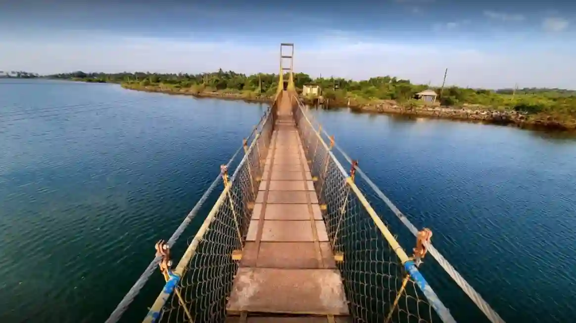
Quick Overview of Pavinakurva Hanging Bridge
| Particular | Details |
| Name | Pavinakurva Hanging Bridge |
| Location | Karki-Pavinakurva area near Honnavar, Uttara Kannada, Karnataka |
| River | Badagani River |
| Bridge Type | Pedestrian suspension footbridge |
| Main Cables | Steel wire cables |
| Primary Use | Local pedestrian connectivity; two-wheelers have also been reported using it |
| Major Nearby Town | Honnavar |
| Highway Access | Via the NH-66 / Karki-Honnavar road network |
| Nearby Railway Station | Honnavar Railway Station |
| Nearby Areas | Pavinakurva, Karki, Honnavar and Haldipur |
| Known For | Suspended walkway, river scenery and village connectivity |
| Exact Length | Not stated here because published figures conflict |
| Visitor Status | Check locally before visiting; current online access listings are inconsistent |
Where is Pavinakurva Hanging Bridge Located?
Pavinakurva Hanging Bridge is located in the Karki-Pavinakurva belt near Honnavar in coastal Uttara Kannada. A specialist suspension-bridge inventory places the structure at Karki and identifies the crossing as the Badagani River.
Pavinakurva is a river-separated locality north of Honnavar. The bridge gives residents a short crossing to the mainland road network, while the surrounding Karki and NH-66 corridor provides access towards Honnavar, Kumta and other coastal towns.
The setting is very different from a city flyover. The bridge is surrounded by water, coconut trees, village roads and low-rise coastal development, which is why it has become popular in travel photographs and short videos.
Pavinakurva Hanging Bridge Route and Road Connectivity
For most visitors, Honnavar is the practical base. Travellers using NH-66 can approach the Karki-Pavinakurva area through local roads before continuing on foot or by suitable local transport near the bridge.
The bridge itself is not a car bridge. Its narrow suspended deck is intended primarily for local pedestrian movement, although two-wheelers have been reported using it. Cars and larger vehicles need to remain on the normal road network.
- Honnavar: Main nearby town and the practical transport base for visitors.
- Karki: Locality closely associated with the bridge and its mainland approach.
- NH-66: Principal coastal highway linking Honnavar with Kumta, Murudeshwar and other towns.
- Kumta: Important coastal town north of the Honnavar-Karki belt.
- Murudeshwar: Major tourism destination south of Honnavar along NH-66.
- Honnavar Railway Station: Main rail access point for the bridge area.
Why is Pavinakurva Hanging Bridge Important?
The bridge’s first role is everyday connectivity. Local accounts explain that Pavinakurva is separated from the mainland by the Badagani River and that the suspension bridge gives residents a much shorter way to reach Honnavar than taking the longer road route.
This kind of small suspension bridge can be particularly valuable in coastal and riverine villages, where waterways divide settlements even when the straight-line distance between them is small. Walking access to schools, markets, work and public transport can become much easier when a dependable crossing is available.
Its second role is tourism. The quiet river setting and hanging design have made the bridge one of the lesser-known attractions travellers include with Honnavar beaches, mangrove areas and backwater experiences.
Traffic and Crossing Conditions at Pavinakurva Hanging Bridge
Normal road-traffic conditions do not apply here because Pavinakurva is a narrow suspension footbridge rather than a multi-lane vehicle bridge. The main movement is pedestrian traffic, together with locally reported two-wheeler use.
Because the deck is narrow, users should avoid crowding the bridge or blocking the passage for residents. Two-wheelers, where locally permitted, should be moved slowly and with consideration for pedestrians. The gentle movement associated with a suspension deck can feel unusual to first-time visitors but should not be treated as a reason for jumping or deliberately making the bridge sway.
Current access should be checked locally before making a special trip. Public online listings in 2026 are inconsistent: some recent travel material continues to present the bridge as a visitor attraction, while another current listing marks it temporarily closed. Visitors should therefore confirm local access before travelling specifically for the bridge.
Structure and Design of the Hanging Bridge
Pavinakurva is a simple suspension footbridge. The deck is carried by a cable system anchored at the ends, with vertical hangers transferring the deck load to the main steel-wire cables.
This arrangement allows a relatively light bridge to cross a water channel without the heavy deck and multiple river piers associated with a conventional road bridge. It also explains the slight movement that users can feel when people walk across the structure.
Published travel pages give very different figures for the bridge’s length, ranging from about 142 metres to around 400 metres. Because a reliable official engineering dimension is not available in the sources reviewed, an exact length should not be presented as established fact.
Pavinakurva, Badagani River and the Honnavar Landscape
The Badagani River is the immediate waterbody crossed by the bridge. Pavinakurva lies within the wider coastal landscape around Honnavar, where rivers, estuaries, islands, backwaters and the Arabian Sea create a distinctive geography.
Karnataka Tourism highlights Honnavar for its suspension bridges, waterfalls, mangrove forests and coastal scenery. The Sharavathi River is the major river associated with Honnavar as a whole, but Pavinakurva Hanging Bridge should more precisely be described as crossing the Badagani River rather than simply calling it a Sharavathi River bridge.
This distinction matters because many online posts loosely use ‘Sharavathi’ for attractions in the wider Honnavar backwater region. For a location guide, Badagani River is the more specific crossing identification.
Tourism and Best Visiting Experience
Pavinakurva Hanging Bridge appeals mainly to travellers who prefer quiet local landscapes rather than large commercial attractions. The combination of still water, reflections, palms and the narrow bridge creates good photography conditions, particularly when the light is softer in the morning or evening.
Visitors should remember that the bridge is used by local residents. Keeping the deck clear, avoiding loud gatherings and not parking vehicles in ways that block village access are more important here than at a purpose-built tourist viewpoint.
Monsoon weather also deserves attention. Uttara Kannada receives heavy seasonal rain, so wet decking, strong wind, high water levels or local restrictions can change conditions quickly. A local status check is sensible during the rainy season.
Public Transport Near Pavinakurva Hanging Bridge
Honnavar is the main transport base for reaching the bridge area. The town lies on the Konkan Railway and on NH-66, giving it both rail and highway access.
Honnavar Railway Station is the most practical railway facility for the Pavinakurva-Karki area. From the station or town centre, travellers generally need a taxi, auto-rickshaw or other local road transport to reach the bridge approach.
Public transport may not take visitors directly to the suspension bridge entrance, so the final stretch should be planned as a local-road journey.
Major Landmarks and Places Near Pavinakurva Hanging Bridge
- Honnavar town: Main centre for accommodation, food, buses and local transport.
- Honnavar Railway Station: Konkan Railway access for the wider area.
- Karki: Coastal settlement adjoining the bridge area.
- Apsarakonda: Popular Honnavar-area waterfall, beach and viewpoint destination.
- Sharavathi Mangrove Boardwalk: Nature attraction in the wider Honnavar tourism circuit.
- Eco Beach: Coastal attraction in the wider Honnavar-Kasarkod area.
- Idagunji Mahaganapati Temple: Well-known religious destination in the Honnavar region.
Nearby Areas to Pavinakurva Hanging Bridge
- Pavinakurva: The river-separated village/locality directly served by the bridge.
- Karki: Nearby mainland settlement and important location reference for the bridge.
- Honnavar: Main coastal town for transport, shopping and accommodation.
- Haldipur: Coastal locality north of Honnavar along the NH-66 corridor.
- Kasarkod: Honnavar-area coastal locality known for Eco Beach.
- Kumta: Larger coastal town north of the bridge area.
FAQs About Pavinakurva Hanging Bridge
Q1. Is Pavinakurva Hanging Bridge the same as Samshi Hanging Bridge?
No. Honnavar has several suspension bridges, and local tourism listings identify Karki/Pavinakurva Hanging Bridge and Samshi Hanging Bridge separately. They should not be treated as the same structure.
Q2. Can cars cross Pavinakurva Hanging Bridge?
No. It is a narrow suspension footbridge rather than a normal car bridge. Pedestrians are the main users, and local/travel reports also describe two-wheeler use.
Q3. Why is the exact bridge length not given?
Published sources conflict sharply, with figures around 142 metres and around 400 metres. Without a reliable official engineering figure, it is safer not to present either value as confirmed.
Q4. Is Pavinakurva Hanging Bridge open to visitors right now?
Online status information in 2026 is inconsistent. Some recent travel sources continue to feature it as an attraction, while another current listing marks it temporarily closed. Visitors should confirm local access before making a special trip.
Q5. Is this bridge over the Sharavathi River?
The more specific crossing identification is the Badagani River. The bridge lies within the wider Honnavar-Sharavathi coastal and backwater region, which is why some informal posts loosely associate it with the Sharavathi.
Q6. Are there several hanging bridges around Honnavar?
Yes. Karnataka Tourism notes that Honnavar is known for suspension bridges, and local tourism sources separately list Pavinakurva/Karki, Samshi and other hanging bridges in the wider area.