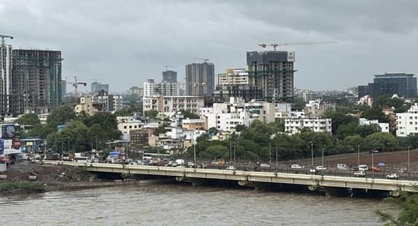
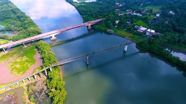
Valapattanam Bridge is a major road bridge over the Valapattanam River in Kannur district, Kerala. The bridge forms part of the long-used National Highway 66 corridor, formerly NH 17, between Pappinisseri and the Valapattanam-Chirakkal side of Kannur. It carries local, regional and long-distance traffic travelling between northern Kannur, Taliparamba and Kasaragod on one side and Kannur city, Thalassery and Kozhikode on the other.
Official bridge records identify the existing Valapattanam Bridge at about km 147.2 of the old NH 17 alignment. NHAI’s bridge inventory describes it as an RCC box-girder structure on pile foundations, with 15 spans and an overall width of about 10.5 metres. A government-backed bridge survey records its year of construction as 1980.
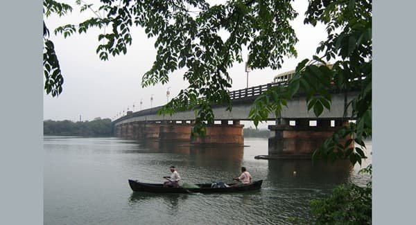
The crossing remains important in 2026 because the older two-lane route continues to carry heavy traffic while the wider Kannur Bypass and its separate new river bridge are being developed. Recent reports have also highlighted potholes, slow movement and recurring congestion on the existing bridge.
Quick Overview of Valapattanam Bridge
| Particular | Details |
| Common Name | Valapattanam Bridge |
| Location | Between Pappinisseri and Valapattanam/Chirakkal side, Kannur district, Kerala |
| River | Valapattanam River |
| Road Corridor | National Highway 66 (former NH 17) |
| Bridge Type | RCC box-girder road bridge |
| Foundation | Pile foundation |
| Approx. Structural Length | About 426.5 metres from the recorded span arrangement |
| Overall Width | About 10.5 metres |
| Span Arrangement | 1 x 8.5 m + 13 x 31.5 m + 1 x 8.5 m |
| Year of Construction | 1980 |
| Main Connections | Pappinisseri, Valapattanam, Chirakkal, Puthiyatheru and Kannur |
| Vehicle Use | Passenger, bus, two-wheeler and commercial highway traffic |
Where is Valapattanam Bridge Located?
Valapattanam Bridge crosses the Valapattanam River just north of Kannur city. The northern approach is associated with Pappinisseri, while the southern side connects towards Valapattanam, Chirakkal and Puthiyatheru. The crossing sits on the established coastal highway route that has historically carried NH 17 and is now identified as NH 66.
Northbound traffic uses the bridge for Pappinisseri, Taliparamba, Payyanur and Kasaragod, while southbound vehicles continue through Puthiyatheru towards Kannur, Thalassery and Kozhikode. A slowdown on the crossing can therefore affect a much wider section of NH 66.
Valapattanam Bridge Route and Road Connectivity
The bridge is part of a continuous north-south road corridor through Kannur district. A typical movement is broadly: Kannur / Puthiyatheru -> Valapattanam Bridge -> Pappinisseri -> Taliparamba -> Payyanur and Kasaragod-side routes.
- Pappinisseri: Main settlement and highway approach immediately north of the river crossing.
- Valapattanam: River-side town and important local road reference on the southern side.
- Puthiyatheru: Busy junction connecting the bridge corridor with Kannur city and nearby suburban roads.
- Chirakkal: Major residential and historic area adjoining the southern side of the wider bridge corridor.
- Taliparamba: Important town reached northbound on NH 66 from Pappinisseri.
- Kannur city: District headquarters reached southbound through Puthiyatheru and the urban highway network.
- Payyanur and Kasaragod: Major destinations farther north along the NH 66 corridor.
Why is Valapattanam Bridge Important?
Valapattanam Bridge is more than a local river crossing. It forms part of one of Kerala’s principal coastal road corridors and connects Kannur city with northern Kannur district and the Kasaragod direction. Buses, private cars, two-wheelers and goods vehicles all depend on this route, so delays at the bridge can quickly spread to Pappinisseri and Puthiyatheru.
Its importance has been recognised for decades. A 1979 Parliament question pressed for speedy completion of the dedicated highway bridge because closures of the older rail-cum-road crossing caused hardship in North Malabar. Later national bridge studies also recorded high traffic demand at Valapattanam.
Traffic Conditions at Valapattanam Bridge
Traffic congestion is a recurring issue around the existing bridge. The crossing has a relatively narrow carriageway compared with today’s six-lane highway standards, and traffic from Pappinisseri, Valapattanam, Puthiyatheru and the wider NH 66 corridor converges on the same structure.
In July 2026, local reports described damaged surfacing and numerous potholes, with vehicles slowing sharply while crossing. Congestion and accidents were recurring concerns, and non-functioning street lighting was also reported at night. Long queues can extend towards Pappinisseri Chungam and the Valapattanam side.
Delays are more likely during commuting hours, school and office traffic, weekends and road-repair periods. Checking current traffic before entering the corridor can be useful when congestion is severe.
Construction and Engineering of the Existing Bridge
NHAI’s NH 66 bridge inventory records an RCC box-girder superstructure, RCC piers and abutments, and pile foundations. Its span arrangement is one 8.5-metre span, thirteen 31.5-metre spans and another 8.5-metre span, totalling about 426.5 metres.
The inventory lists the bridge width at about 10.5 metres, while a national bridge-sector survey records 1980 as its construction year. These figures refer to the existing road bridge, not the new Kannur Bypass crossing.
Maintenance and Current Road Condition
The bridge has undergone strengthening and repair at different times. NHAI’s 2017 survey recorded strengthening work in progress and described the superstructure and substructure as being in fair condition at that time. Earlier inspections had also identified repair needs in concrete, expansion joints and pavement.
The July 2026 pothole reports concern the driving surface and should not be treated as a current structural certification. Drivers should follow speed limits, barricades and temporary controls during maintenance.
New Valapattanam Bridge on the Kannur Bypass
A separate six-lane bridge is being developed across the river as part of the Kannur Bypass. It runs from the Pappinisseri Thuruthi side towards Chirakkal-Kottakunnu and should not be confused with the 1980 road bridge.
Its design was revised to provide better clearance for future inland navigation. Later project reporting described the river portion as about 727 metres long with 19 spans, including a wider central navigation span.
Once fully operational, the bypass should divert more through traffic. The existing bridge will still matter for the established Pappinisseri-Valapattanam-Puthiyatheru route.
Public Transport Near Valapattanam Bridge
Buses travelling between Kannur, Taliparamba, Payyanur and northern destinations use the wider NH 66 corridor, while local buses and autos serve Pappinisseri, Valapattanam, Chirakkal and Puthiyatheru.
Valapattanam and Pappinisseri railway stations serve opposite sides of the river corridor. The railway and road crossings are separate structures.
Major Landmarks and Facilities Near Valapattanam Bridge
- Valapattanam River: The large river crossed by the highway bridge.
- Pappinisseri Chungam: Busy road point north of the bridge where queues can develop.
- Valapattanam town: River-side settlement immediately associated with the crossing.
- Puthiyatheru Junction: Major traffic junction on the approach towards Kannur city.
- Valapattanam Railway Station: Rail access point on the southern side of the river corridor.
- Chirakkal: Important nearby area between Valapattanam and Kannur city.
Nearby Areas to Valapattanam Bridge
- Pappinisseri: Immediate northern approach area and a major reference point for the bridge.
- Valapattanam: Town on the southern side of the river and the locality from which the bridge takes its name.
- Chirakkal: Residential and historic area south of Valapattanam.
- Puthiyatheru: Busy junction and suburban commercial area on the route towards Kannur.
- Azhikode: Coastal-side locality accessible through connecting roads from Valapattanam and Chirakkal.
- Kannur: District headquarters and the main city south of the bridge.
FAQs About Valapattanam Bridge Kannur
Q. Is Valapattanam road bridge the same as the railway bridge?
No. The road bridge carries NH 66 traffic across the river, while the railway line uses a separate nearby crossing. Photos taken from trains can make the two easy to confuse.
Q. Will the new Kannur Bypass bridge replace the old Valapattanam Bridge?
The bypass is intended to carry the upgraded NH 66 route and reduce pressure on the old corridor. The existing bridge remains useful for local traffic between Pappinisseri, Valapattanam and Puthiyatheru.
Q. Why can it take a long time to cross Valapattanam Bridge?
It funnels heavy north-south traffic through a comparatively narrow older crossing. Potholes, road works and approach queues can reduce speeds further.
Q. Is Valapattanam Bridge suitable for sightseeing on foot?
It is a busy highway bridge, not a pedestrian tourist attraction. Use designated pedestrian space where available and do not stop on the carriageway for photography.